2021-04-30 50 19
| Fri 30 Apr 2021 in 50,19: 50.2664040, 19.8683606 geohashing.info google osm bing/os kml crox |
Location
Forest north of Sobiesęki village, 30 km north of Kraków, near Ojców National Park.
Participants
Plans
I had a day off today. When I noticed that geohash would be close to Kraków, and the weather would be nice, I decided to take a bike trip there, cycling through Ojców National Park and a beautiful valley.
Expedition
I departed in the early afternoon. While leaving Kraków, I got stuck for a moment in a traffic jam on one of local roads going north (two big road constructions are ongoing in this area), but finally I was free. Kraków is located in a valley and the regions to the north and south from the city have a much higher attitude, therefore most of my way to the north was climbing and I did not ride very fast. The weather was beautiful, and once I entered Ojców National Park, I frequently stopped to take some photos, taking advantage of perfect sun.
An interesting fact is that I was walking the very same trail only a week ago, and it turned out to be also a geohash expedition :). The trail is also a part of The Way of Saint James called Via Regia that goes from the Ukrainian border, crossing Poland from east to the west, ending in Geisa in central Germany. Actually, I walked all this way up to Santiago about 3 years ago - the section from Kraków to Skała town was my first stage and I always think about it whenever I visit this area.
But going back to geohash. After crossing Ojców village, I left the valley and climbed to Skała town. It was the highest point of my expedition. There, I took the direction to the north, to Sobiesęki village and to the forest behind it. I left the forest road about 400 meters from the geohash, only to discover that there is one more unmarked path that leads me almost to the hashpoint. The last 50 meters were challenging, because I had to walk with my bike through some bushes. The hashpoint turned out to be a stack of branches hidden among the trees. I took some photos and travelled back home, following the same track. This time it was much faster, because I was mostly going down. The total travelled distance in both directions was 75 km.
Photos
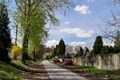
Giebułtów village, leaving Kraków and climbing
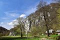
Rock formations in Ojców National Park
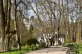
Park in Ojców, historic hotel and a castle visible behind the trees
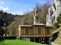
Famous chapel on the water, built above the river

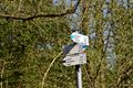
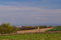
Sobiesęki village, hashforest visible on the horizon
1,5 km from the hashpoint, the forest is full of trails
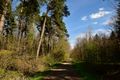
Forest road to the hashpoint
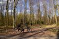
Time to leave the road
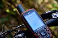
Proof
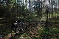
Hashpoint
Going back, Kraków visible in the valley


Achievements
Zyxist (talk) earned the Bicycle geohash achievement
|