2021-06-11 -37 145
| Fri 11 Jun 2021 in -37,145: -37.6035520, 145.1620612 geohashing.info google osm bing/os kml crox |
Location
Just inside a paddock next to a creek, in Doreen, in Melbourne's outer northern reaches.
Participants
Plans
Friday marked the first day out of Melbourne's latest lockdown. Instead of being confined to exercising within a 10km radius, we were now allowed up to 25km. How far is this geohash from my house? About 24.9km. I couldn't not go!
After a week of catastrophically terrible weather, I was also really itching to get out and stretch the legs.
Expedition
I did a bit of half hearted route planning and set off on my bike, carrying warm clothes, two bananas and the usual insufficient quantity of water. Taking a weird way to the Main Yarra Trail, I came across a spectacularly rough, potholed asphalt road, which reminded me nostalgically of American cities. The kangaroos, wallabies, magpies and noisy miners along the trail didn't, though.
Along the trail, flashes of past expeditions came to me, and nagging half-forgotten memories spurred by particular riverside spots - had I stopped by that particular tree for some reason? What was significant about that muddy slope?
Not many cyclists but lots of walkers. Little dogs, big dogs, old people, high school students, sometimes in clumps, sometimes alone.
I marvelled at just how unclear the trail signage is, despite apparent recent efforts. Is it really so hard? Even for a trail that I have ridden quite a few times over the years, several times I reached an unlabelled intersection and had to check my map. The Diamond Creek Trail was better signed, but somehow harder to follow: random bits of path that didn't feel like the same trail, sudden diversions onto road.
At Diamond Creek (the town), I left the trail and suddenly remembered that this area is really hilly. Probably good for me. Lots of cars, but they were pretty polite. A gorgeous purple and orange sunset appeared over every crest.
Suddenly the road quietened a lot, as I passed some invisible threshold. I admired ancient European conifers, open fields, mansions with grand views, eyesores under construction.
I reached my first dirt road, pondering how I once would have zoomed full speed over all the mud and ruts in the fading light, while today I took it easy, enjoying the thrill of not ending up sprawled in the mud, covered in grazes.
Finally Three Hut Road - where I did not see any huts, perhaps because I misheard the name as Three Hat Road, and was focused on hats. A furious descent to a narrow creek. Fortunately no need to climb the other side.
The hash was only 15 metres inside the fence, with no houses in sight. Excellent. I quickly ripped my knicks on the barbed wire and got straight to the point. I'd anticipated arriving in darkness, but was pleased to be able to get a few photos.
Return
I didn't really fancy a 3 hour ride in the dark to get home, so I took the shortest-ish route to Mernda. Somehow, once again, I found myself on a narrow muddy goat track running alongside a steep slope, but managed to dismount gracefully without crashing.
The final excitement was reaching the station with 1 minute till my train left. I scurried to the nearest escalator, to discover it was actually a gigantic set of stairs. Imagining a long wait for the next train, I hoisted the bike and ran full pelt up the whole staircase, making the train, which anticlimactically then sat around for an extra couple of minutes. The times we live in.
Tracklog

Photos
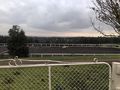
Just missed capturing sunset over this dressage field.
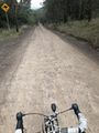
First dirt road.
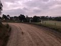
Brocks Road, getting close!
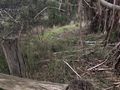
View of the hash from outside.
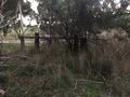
View of the outside from hash.
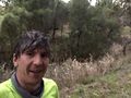
Success!


Achievements
Steve earned the Bicycle geohash achievement
|