2021-06-24 -38 146
| Thu 24 Jun 2021 in -38,146: -38.2301366, 146.2767899 geohashing.info google osm bing/os kml crox |
Location
A secluded glade on a cattle farm in the Strzelecki foothills.
Participants
Plans
Expedition
"Potentially good hash for Matt", "Looks pretty doable", "Oh yeah, ideal Matt one". The group chat burst into life first thing in the morning.
I checked the app. Sure enough, only a couple of k away, and the google map had a road right next to it. I'd never ridden that road, I'd never realised it was there. Why on earth not? I'd ridden every other road in the vicinity.
But the rain beat cold against the window. I wasn't going out in that. It would clear by noon, maybe I could duck out for a quick ride in my lunch break.
It was the right choice. By lunch, the sun was out, the sky was blue, and as I rode out the drive a couple of wedgies circled high above. A good omen - or was it - the Prime Minister's homily on taking inspiration from an eagle had elbowed its way into my mind. Shit. Focus - the sky is vivid blue, there's a funny looking alpaca, beautiful eastern rosellas dart across the road in front of me. Back in the moment.
Coalville Road snakes its way up the Narracan Creek, also following the former Thorpdale railway line. At parts, you can still see the cutouts or embankments used to keep the train line flat, or ruined tresle bridges over the creek. The road undulates along the side of the valley, twisting in and out of bush, forest and farmland. It's a good sealed road, and you're more likely to encounter a wallaby than a car. It's quite possibly one of my favourite roads in Victoria to ride, and somehow, after almost 3 years of living here, it hasn't lost its magic.
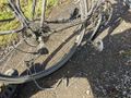
I can see now why I've not ridden the road past the hash before. It looks like a driveway. And the road is only on google, none of the other maps. Well, worth a look. I turn off Coalville Rd and start working my way up the steep gravel track. But - disaster - broken chain!
The driveway leads to a house, as I discover when I press on on foot. Checking the map again, I see my mistake. The "road" mapped on google is a couple of muddy tyre tracks in the paddock next door. Continuing on foot would've been the only option anyway.
A quick vault of the fence, and I'm off following the track. A few cows give me curious looks, but I decide it's not worth my time explaining geohashing to them. They'd probably freak out when I get to the part about the stock market.
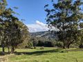
It's a beautiful track. The walk to the point is very simple, up a valley wall, over a saddle with fine views of the area, through a copse and into a secluded glade, known only to me and a dozen cows. A few electrified fences threaten to spoil my attempt but convenient gates are to be found with only slight diversions.
So close to home yet somewhere I'd never seen before. And returning along Coalville Rd at walking pace gave me a new appreciation for that road too. A grand adventure.
Tracklog
Photos
The wedgies circled above.
Oh no - would my plans be thwarted?
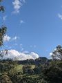
The farm track climbed out of the valley up the side of a hill.
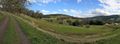
Having climbed the track up the hill, looking back gave fine views of the valley.
Proof!
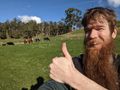
At the hash point with the cows.


