2021-06-24 41 -73
| Thu 24 Jun 2021 in 41,-73: 41.9681678, -73.9011025 geohashing.info google osm bing/os kml crox |
Contents
[hide]Location
Beside a pond off of Route 9G in Rhinebeck, New York.
Participants
Expedition
I was hoping that one of these days there would be a geohash near Kingston that I could reach, since I recently left my credit card in a restaurant in Kingston and a geohash would be a convenient excuse to drive there. Well, today was the day, so I set out to Kingston first to pick up my card, and then went back across the Hudson to reach the spot. When I had checked in the morning, the map view on Google Maps made it seem like the spot was in a pond, but the satellite view seemed as though it was just on the banks of the pond. I knew that the expedition could end in failure, but I figured I would be close enough to the spot anyway where it was worth the risk.
After initially missing the turnoff for the road, I parked right by the pond and observed my surroundings. There was a fair bit of brush off the side of the road before the pond started, so it was feasible that the actual spot was on dry land. As I waited for Google Maps to zoom in and find where I was, I noticed it was acting a bit under the weather. We certainly weren't in the middle of nowhere, but for some reason my cell data wasn't quite working, so I couldn't zoom very far in to see where I was without the picture blurring up. Pretty soon, the satellite view on my phone stopped working entirely as my phone just gave up on accessing the interwebs.
Usually, Google Maps is my primary way of checking whether I found the hash, but the Compass app is also helpful. Unfortunately, I committed a cardinal sin: I didn't write the hash coordinates down. Big mistake. So, I just wandered around the bank of the pond, hoping I had stumbled upon the spot, taking pictures and screenshots all the while. I also saw a couple really big fish (I assume carp) and a heron that gave those fishies a good fright. Not a bad wildlife selection for a little ol' pond. Eventually, I said to hell with it, and hoped that when I got home, I would find out the coordinates were where I'd been.
When I got home, the moment of truth revealed that I wouldn't qualify for a Blinded by Science consolation prize: I had taken a compass screenshot right on the correct coordinates! It made sense, since the satellite view made the spot appear to be out of the water. Next time, Google Maps is getting a timeout to get its mind right, and I'm gonna write down the coordinates or suffer the grievous consequences.
Photos
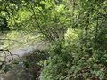
Here's looking at the actual spot, having forensically deduced it after the fact.
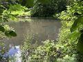
That fish is pretty menacing, right? I thought it was a barracuda or something at first.
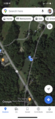
This was before the map crapped out on me, when I could see the label I placed.
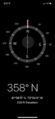
Good ol' compass. What would I do without you?


Achievements
This user earned the Land geohash achievement
|