2021-07-08 50 7
| Thu 8 Jul 2021 in 50,7: 50.2833391, 7.5784299 geohashing.info google osm bing/os kml crox |
Location
In a forest near Waldesch
Participants
Plans
Bike to Waldesch, quickly go to the hash and ride back.
Expedition
After having had my arm in a cast for the last several weeks, it finally was removed a few days ago and I was very eager to be able to ride a bike again. With the hashpoint being located relatively near to my home this was also a nice opportunity to test my practically unused e-bike which I had bought just previous to braking my wrist🙄.
However, the weather was really bad for most of the day and I even received several official weather warnings which mentioned severe rain, thunderstorms and even hail. And it did indeed rain quite a bit and I definitively heard thunder. But luckily, the storm and hail never came and the worst rain calmed down again quickly so I was able to start hashing. My home and the hash location was apparently not in one of the really badly affected regions.
But first I had to test if I was even able to ride the bike. So I carefully tried how riding, turning and crucially braking was possible with my still weak wrist in my backyard. To my surprise it was no problem at all! The rain was also down to just a few single drops which were more then tolerable and It didn't look like it would increase so I was good to go.
I had looked up a few routes on maps and chose the shortest one. But after just a few hundred meters I reached the first of what would become very many dead ends. The road was completely fine and would have been great to ride on (even if it was steep uphill), but there was a very unambiguous sign prohibiting the use of vehicles, which also includes bikes. Then I noticed, that Google Maps had actually displayed a road parallel to the one I was standing in front so I was happy to oblige the sign and carry on.
I don't have a handlebar-mount for my phone yet, so I looked at the next few turns I had to take, memorized them and drove along a very nice path. But shortly thereafter, I realized that a junction which should have been there simply wasn't. So I was on the "wrong" way. I didn't want to turn around to look for that mysterious junction. Also there were signposts practically everywhere indicating where this bicycle path led to, so I decided to just go along it and accept a longer than planned route. this was also the point where I thought it might be a good idea to turn the GPS tracking on, so retracing my steps would be easier if necessary.
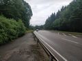
Everything went fine until I came near to Pfaffenheck, where Santu and I had been hashing before. At a tunnel under the Autobahn 61, I knew I had to go to the left through it to stay generally in the right direction. But both the signposts as well as my maps indicated I should not go there and keep right instead, so I did. This led me to the central junction of Pfaffenheck, where Google suggested to bike along the B-327. This would have been legal, but also enormously stupid since there was heavy traffic.
So I turned around, drove back to the tunnel and this time went trough it, and after a short time the path which went parallel to the big road just stopped. There was an opening in the guardrail and I would have had to cross only a short segment, but again I did not want to get on that big of a road under those traffic and weather conditions.
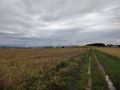
My maps indicated there were several bigger and smaller forest paths I could use instead, so I tried to go along them. This went basically fine, but I had to stop often to look a the maps and compare my location to the surroundings and more than once I was surprisedly discovering that I was not were I thought I were. It was however no big deal and easily fixable most of the time.
I even found some very nice places along the road, including a wooden statue of a hunter using binoculars. However, this area of the forest was still very wet and muddy. My bike is only intended to be used on concrete or tar surfaces! Still, I managed to drive along most paths and could even navigate through an overgrown segment. I had made sure it was only about 100m long and going around it was far more effort than just pushing my bike along.
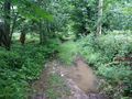
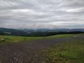
Eventually, I reached a concrete road which led me directly towards the hashpoint. About 150m infront of it I could use a small trail entrance as "parking spot" and went along on foot. The terrain was wet, overgrown and full of fallen down branches, but it was not too hard to get through it, and I managed to reach the hashpoint without further issues.
On my way back to my bike I noticed that I had chosen the worst possible route in the forest as there was a nice, unmarked trail leading to a hunters high-seat just a few meters to north. At least I could use it to get back a bit easier.
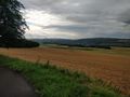
Then I drove straight into Waldesch and then finally took the road I initially wanted to be on. It was a great pleasure riding along it. The underground was nice and there were several very spectacular views along the way. Especially the clouds forming and slowly rising from the meadows nearby was really cool and all the pictures cant really capture how great it looked in person.
But even on the nice big concrete bike-paths there were really deep puddles and water basically everywhere. Even though the bike has a mudguard, my feet and lower legs got really soaking wet along them. I didn't mind. It was only a few km left to go and most of it downhill, so I didn't even really try to keep dry.
To my big surprise, the path back led me exactly to spot where I had first turned around because of the "no vehicles"-sign. Only this time I came from the other direction and there either was no such sign on the other end or I simply have not seen it. Therefore: If anyone asks, I was of course *pushing* my bike, not riding it ;)
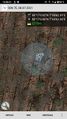
Tracklog
Photos
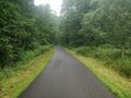
nice road to start
dead end
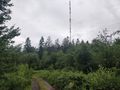
radio tower
bike through there?
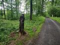
binoculars guy
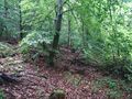
difficult terrain
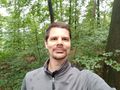
StupidGrinTM
proof
A-61 bridge in the background
(invisible) castle in the background
nice view despite the clouds


Achievements
Gefrierbrand earned the Land geohash achievement
|
Gefrierbrand earned the Bicycle geohash achievement
|
Gefrierbrand earned the Drowned Rat Geohash Honourable Mention
|