2021-08-08 43 -78
| Sun 8 Aug 2021 in 43,-78: 43.2895000, -78.1495448 geohashing.info google osm bing/os kml crox |
Contents
[hide]Location
N of Albion, at the edge of a field on Lattin Road
Participants
Expedition
When the hashpoints were posted on Friday, I reservedly looked them over with an eye on today's points. I have had many expeditions on the 6th, 7th and 9th of August, but never on my Hashiversary. This point appeared to be reachable (although the street-view was taken 10 years ago so it was likely the field would now be Posted). However, I didn't want to drive 70+ miles just for the Geohash. I did need to get a water filter for hiking and had some rewards to use from the previous year at REI so I thought I might be able to combine this with a trip to Rochester.
My girlfriend initially had some plans for today, so I didn't think this would actually happen, but when her plans fell through, she was more than happy to take the drive with me. As in the past, she was also amicable to take a bit of a detour to try for this Geohash! She has a friend in Rochester that she hasn't seen in a while, so we were also able to coordinate for a late lunch at Sticky Lips (a fantastic BBQ place not far from REI).
We headed out around 10:15 and without any trouble, we were able to find the Hash-road around 11:30. As we drove down toward the hash, I could see the Posted signs on the telephone poles along the edge of the field. J pulled off the road near the hash, but decided she didn't want to trek out to the actual hash, leaving that task to me. I clearly was going to have to wait another year to try again, but still wanted to see how close I could get. Turns out we parked one pole short of the hash, so as I was walking up, I was also a little disappointed to see I wouldn't be able to cheat much either with a wide Circle of Uncertainty as I had a pretty good signal for the HashDroid app.
Getting level on the road, I stepped into the ditch and walked as close to the field as I could while staying on the 'maintained' part of the road. I was shocked to see the blue dot continue moving forward into the field and right next to the hash! By moving toward it, the technology didn't realize I stopped and got close enough for a Successful reading! That's why you get out of the car, my friends! It only took 7 years, but I finally have the Hashiversary Ribbon!
After excitedly taking the rest of the pictures for proof, we continued our journey to Rochester and REI. It's a smaller store here, so it didn't take too long to wander all the way through and get our stuff. With about 45 minutes to kill before our 14:00 scheduled lunch, we decided to check out a 'nature trail' on the Monroe County College campus. It was basically a stone path that led under the highway and to the Erie Canal. It was a bit buggy so we turned around a few minutes before we needed to and headed for some celebratory beers and BBQ!
What a great day!
Photos
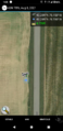
The successful reading of a Hashiversary!
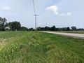
View North.
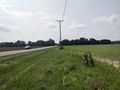
View South and J in the waiting hash-mobile.
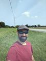
Very happy Hasher.
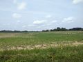
Stepping back to the road, a view of the Hash and field.


Ribbons
This user earned the Land geohash achievement
|
Pedalpusher earned the 7th Hashiversary achievement
|