2021-08-15 42 -78
| Sun 15 Aug 2021 in 42,-78: 42.2479957, -78.7080869 geohashing.info google osm bing/os kml crox |
Contents
[hide]Location
In the woods of McCarty Hill State Forest
Participants
- Pedalpusher
- Simon the dog
- Myka the dog
Expedition
Much like yesterday's Expedition, I knew this would be reachable, but this would be a further walk through the woods. It would also have to wait until the afternoon as I was volunteering with the annual Skyride Buffalo in the morning. Normally, we have this event in the spring, but it was postponed this year due to the pandemic. This being the first time back on the bike since my accident and ankle injury, I took it easy and only did two laps around. I was supposed to be in charge of a group of volunteers that would help at the ride intersections to prevent cars from entering the ride, there really wasn't anything we needed to do as there were police cars stationed at each spot so we just got to enjoy the ride.
Getting back home around lunchtime, I made some pizza dough for dinner and had a sandwich for lunch before loading the dogs in the car to head out for another adventure. Hopefully this time without pokey things...I also learned my lesson yesterday and wore sneakers instead of my hiking boots; my ankle was very happy with that decision.
Finding the pull-off near the edge of the State Forest, we parked off the road and started up the hill on the old forest road. Even if the gate was open, the road was far too steep and overgrown for me to attempt to drive up it. Getting to the first turn, we headed into the woods toward the hash. Again my GPS seemed to be acting up, but was at least pointing sort of in the right direction this time. I don't know if it was the slope of the hill or what, but it felt like we weren't walking in the right direction, but the distance to the hash kept dropping as we followed the GPS.
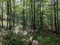
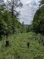
Getting closer, we ended up in a more open area of the forest that was covered in thorny but stubby raspberry bushes. I think this area had been logged a very long time ago, and now that the trees had grown, they were shading more and more of the forest floor. This stunted and seems to have started the demise (in a couple more years) of the raspberries growing in this area. Unfortunately, we still had a ways to go through this short but spiky undergrowth and to prevent a big GPS dance, I again pulled out my phone and used the HashDroid app. Working our way around, I was able to get a good reading relatively quickly and got some pictures. I then turned toward the general direction where I thought the road was and started heading back. I may have still been a little turned around, but I also wanted to not go back the way we came through those pricker bushes so we headed off to the side.
As we got out of the hash area, we came across the largest ferns I ever saw. I got a picture with Myka for scale and was on high alert for raptors as it appeared we stumbled into the Jurassic period for a moment. Continuing on our way, I watched the HashDroid app and it appeared we were going in the correct direction so I put away the phone for a bit. After a while and like the day before, we came across another trail in the woods. We started following it thinking it was going in the right direction, but pulling out my phone after a while, I realized this was heading toward another forest road, but not the one we had parked at. Breaking off and heading downhill, we came across what appeared to be an old logging road, and this was definitely going in the right direction. After confirming on the phone a couple times, we broke out of the woods at the end of the road we were looking for. I'm kind of glad we got turned around and sort of lost as I now have a new area of this forest and a trail to explore next time!
Heading downhill, we got back to the car, but because it was such a warm day, I decided to drive further into McCarty Hill to the top where there is a large lake that Holliday Valley uses to cover their skiing hills with snow in the Winter. The dogs enjoyed their cooling swim before we headed for home and the promise of home-made pizza for dinner.
With nothing reachable or reasonably close the next day, the consecutive hashing ends here.
Photos

SkyRide in the morning with the Downtown Buffalo in the background.
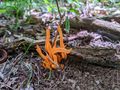
On the way to the hash, we found these Orange Coral Mushrooms growing.
Made it!
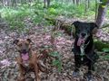
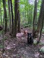
The dogs at the Hash.

South(ish?) view from the hash.
West(ish?) view.
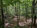
View of the Hash.
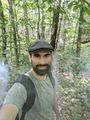
Standard Stupid Grin.
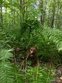
'Rawr!'
New trail we found in the woods!
Made it back to where we wanted to be, finally; on the way down to the car.
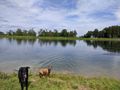
Playing in the water with the top of the Spruce Lake Quad chair in the background. It was running for chairlift rides today.


Ribbons
This user earned the Land geohash achievement
|
Pedalpusher earned the Consecutive geohash achievement
|