2021-08-20 -38 146
| Fri 20 Aug 2021 in -38,146: -38.3865472, 146.0464257 geohashing.info google osm bing/os kml crox |
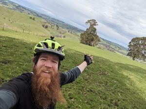
A few metres into a paddock on the side of a Strzelecki hill.
Contents
[hide]Participants
Expedition
It's hard to overstate the brilliance of the Western Strzeleckis as a cycling destination. The curious cyclist, with no particular route in mind, can merely head into the hills and take whatever turns they please, guaranteed of spectacular scenery, challenging climbs (and thrilling descents), birdlife and farmlife galore, and maybe even some roos, wallabies, emus and wombats.
My ride to the geohash was not quite so undirected, but nevertheless I was stunned once again by just how reliably this region delivers.
I began the ride with my oft-ridden Coalville Road, which gradually climbs the Narracan Creek valley, twisting through groves of wattle - brilliant yellow at this time of year - and bending around treefern-studded rivulets trickling down to the creek below. The road ends suddenly at Narracan by a disused church, where I began the climb out of the valley, joining McDonald's Track.
McDonald's track was cut in the early days of white settlement, as a stock route from Lang Lang to Morewell. Soon after construction, however, the folly of constructing it along a ridge line became apparent, as there were no permanant water sources en route for the cattle. It immediately fell into disuse and was mostly overgrown, though major portions of it have been recovered now as roads.
I could've followed McDonald's track for some time, but I opted instead to detour to Thorpdale for a pie - if you're ever in the area, they are really good pies, try one.
A couple of clicks out of Thorpdale I once again joined McDonald's track. The drizzle was clearing, and as I climbed, the hills in front of me unfolded one by one, emerging out of the mist and glinting in the sunlight. At the far end, I imagined I could see Mt Worth, the highest peak in this region at 515m.
I left McDonald's track - for now - and descended down the side of a small valley to the microtownship of Allambee, a one-room school and a few farmlets nestled around a forested creek, and where I would briefly join the famous Grand Ridge Road, and then the Old Grand Ridge Road, an unsealed alternative for a few kilometres.
Finally, I turned towards the geohash. It was on the south side of the ridge, and there were no higher points between it and the coast. As I approached through tall eucalypt forest, I got occasional glimpses of the view, and my excitement began to mount. Finally, at the last moment before the hashpoint, the forest fell away and I was struck with the full expanse of the view before me. Pastoral lands rolled down towards a distant highway, and more hills rose beyond. In the distance, the land and sky - and sea? not sure - melted into a haze of blue.
The hashpoint was easy enough to get. I jumped the fence and wandered a few metres into the paddock. A few cows were idly curious, but didn't take too much of an interest - probably good, because there was a bull amongst them too.
I try to avoid, where possible, retracing my route too much, so I continued on the road I was on, and ended up returning via a longer route that wound around and summited Mt Worth. The climb up Mt Worth is spectacular - in one moment you're in a ferny glade with water trickling over the rocks above the road, the next, you've turned a corner and towering mountain ash evoke a renaissance cathedral, light filtering through the leadlight folliage above. The reward for the climb is a panoramic view north, to compliment the earlier southern vista, taking in the Latrobe Valley and the dominating Baw Baw Plateau rising behind.
Once again I was briefly reunited with McDonald's track as I contoured around the north side of the range, before losing all my hard work in a matter of minutes as I descended steeply towards the valley floor.
As I settled in for the grind back home, I reflected how lucky I was to be able to enjoy such world-class rides right on my doorstep. Fantastic!
Tracklog
Photos
Achievements
mdixon4 earned the Bicycle geohash achievement
|


