2021-08-31 43 -102
| Tue 31 Aug 2021 in 43,-102: 43.4309714, -102.1793952 geohashing.info google osm bing/os kml crox |
Contents
[hide]Location
Next to a Reservoir in Kyle, SD
Participants
Expedition
This is the first Expedition on my Epic Road Trip with my Girlfriend J. After flying into Denver on the night of 2021-08-27, we Cliff Camped in Estes Park, CO on 08-29 before driving up to the Badlands in South Dakota. The first night of camping was REALLY bad. DO NOT tent camp in the Badlands during the summer if you visit; There are regular windstorms and lightning. We wondered if the tent would survive the heavy winds and I had to hop out a couple times to adjust and re-secure the tent. Then the thunder and lightning was getting closer so we bailed out and spent a couple hours trying to sleep in the car. Around 03:00, the winds died down and we moved back to the tent and got some sleep. The plan was to go to a sunrise hike at the Door trail (like I did with my friends on a previous road trip) and then make some breakfast at the campsite.
We managed to drag ourselves out of bed, but got to the trail a few minutes late. There were a bunch of people out on the trail but we were able to find a nice spot to ourselves to finish watching the sunrise and the colors change across the geology of the Badlands. We hit two more short trails before getting breakfast where I discovered a close and what appeared to be easily accessible Geohash! J was willing to drive over with me and we decided to try for it early in the afternoon (we wanted to nap and relax a bit after not getting much sleep).
Around lunchtime, we jumped in the car and I set my phone GPS to the spot while J made us peanut butter and jelly sandwiches. Heading out of the Badlands, I ended up missing a turn but didn't notice. J commented that suddenly the trip time was way higher along with the distance. We figured out that Google was trying to send us WAY down the road to do a U-Turn and then drive back, so we just turned around right there and fixed the situation. Back on track, the GPS looked much better and we found our way to Kyle without any other issues.
Getting through town, J was a little concerned when we started driving down the dirt road toward the reservoir, but I assured her we were still on public roads and there weren't any signs indicating otherwise. Parking at the pull-off, I could see this would be an easy success as the hash was just up the hill in some long brown grass. Walking up, I was able to get a great reading on the HashDroid app for the first successful expedition in the Pine Ridge, SD Graticule!
Since the day was only going to get hotter, we headed back to the Badlands and went on another hike before having another rough night (more lightning, but the winds weren't quite as bad). The next day, we did Mt. Rushmore, the Crazy Horse Monument, Custer State Park and hit a Spa for a soak in Hot Springs, SD.
We were able to hit a couple more Geohashes on our trip so you can read about the next segment here.
Photos
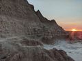
Sunrise on the Door Trail.
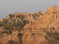
Morning Sun on the surrounding geology.
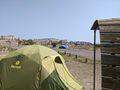
Before leaving for the Geohash, a view of our campsite at the Badlands.
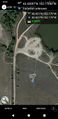
The 4th day of our epic road trip, we successfully got to the Geohash!
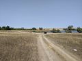
View North, toward the rented and newly minted Hash-Mobile.
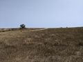
View East from the hash.
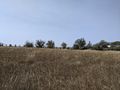
View South toward a construction company (headquarters?).
View West from the hash.
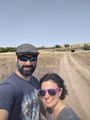
Stupid Grins at the hash!
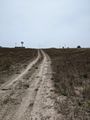
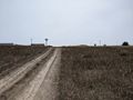
Walking back to the car, a view of the hash (to the right of the tracks).
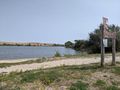
View of the reservoir before heading back to the Badlands.


Achievements
This user earned the Land geohash achievement
|
Pedalpusher and J earned the Graticule Unlocked Achievement
|