2021-10-30 -37 145

| Sat 30 Oct 2021 in -37,145: -37.8238133, 145.3923101 geohashing.info google osm bing/os kml crox |
Location
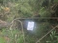
In a park near the dam wall of Silvan Reservoir.
Participants
Expedition
I woke up at 6am and was out the door and on my bike at 7am with a plan to ride out to Mount Dandenong, up and down a few of the faces and then meetup with family in nearby Tecoma in the afternoon. I was somewhere around Box Hill when I thought to check the geohash and was pleasantly surprised. 30km from where I was and within 2km of my planned route.
I paused for a snack when I got to The Basin and did a little bit of research. 7km to go, but it was on mountain bike trails well away from any bitumen, it had rained the night before and I was on my roadbike with skinny tyres. I recently made a promise to myself that I would start taking care of my road bike and not take it for rides in the mud, but I knew the promise couldn't last forever. I consulted clean-bike-enthusiast, mountain-bike-trail-conservationist and fellow geohasher tAlex and he instisted that geohashing was the right thing to do.
Up the 1:20 to Sasafrass and along the ridge to Kalomara. I found a look out with a clear view to Silvan Reservoir and approximately to the hash. I then descended Barbers Road which was very steep, but smoothy and sealed but found myself riding in moist gravel of Olinda Creek Road pretty quickly. I turned off onto Road 14 which followed the edge of the national park and had to walk up some steep clay. The road deteriorated and headed down hill, the clay was very slippery and I stacked. The clay was also very soft so no damage was done, but it did enter places no clay should ever be.
I found the hash in a paddock, the maps said it was on road 14, but I think the maps are a little wonky.
"Road 14" had not been the kindest road on the way in, so rather than go back out the same way I followed it through. I was very close to Track 12 and Track 13 in the mountain bike park which sounded like more fun. No car has been down road 14 in a very long time, the road completely disappeared and found my self bushbashing through bracken and sword grass. I briefly regretted bringing my road bike, but no bike was going to make it over the logs I had to climb so atleast it was nice to have a light bike to lift. After 35 minutes of scrambling I emerged, I climed over a crushed, locked gate with a sign suggesting I shouldn't have gone that way and spotted 2 mountain bike riders. They were confused by my choice of bike and route and gave me directions down the least inappropriate path back to Olinda Creek Road.
Half way up the hill I felt a sharp pain in my foot. I pulled over and retrieved a leech. I only made it a few more hundred metres and then had to stop again when I spotted a duck with a pile of ducklings bike the side of the road. Does anyone know what a pointy beaked duck is called?
I continued up the hill to Olinda where I enjoyed some bakery snacks, then down the other side to meet my sister in Scoresby. We road back out into the hills to visit family and then rode home via the magnificent Djerring Trail.
Tracklog
Photos
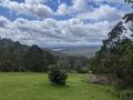
View towards the hash from Kalorama
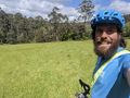
Lachie at the hash
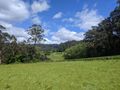
The hash-field
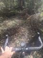
Don't take track 12
Crushed Gate
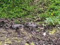
Pointy Billed Ducks


Achievements
Lachie earned the Bicycle geohash achievement
|