2021-12-10 -38 146

| Fri 10 Dec 2021 in -38,146: -38.2661391, 146.1575474 geohashing.info google osm bing/os kml crox |
Location
In a snow-pea farm near Thorpdale
Participants
Expedition
Another geohash perfectly-placed to encourage a splendid bike ride. Rhonda was keen to join, so we waited til after work, and headed out in the golden late afternoon light.
Encountered a couple of yellow-tailed black cockatoos, some echidnas, and plenty of colourful parrots as we worked our way up Coalville Rd, up the hill to McDonalds track, and other such pleasant quiet routes.
The hash was in the middle of a paddock; the satellite pictures showed cows grazing in a grassy field, but when we arrived we found it was now a flourishing snow pea crop. We worked our way up and down the hill along the main paths, not wanting to traipse through the crop, but eventually we arrived at the hash, by the side of a shed.
Then, over the hill and down the long descent into Trafalgar, where we refueled on Chinese then rode home in the dark.
Tracklog
Photos
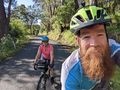
On our way!!
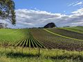
A potato crop by the side of McDonalds Track.
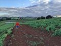
Working our way through the snow peas.
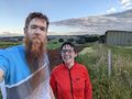
At the hash!

Proof


Achievements
Matt and Rhonda earned the Bicycle geohash achievement
|