2021-12-13 53 10
| Mon 13 Dec 2021 in 53,10: 53.7406482, 10.0003796 geohashing.info google osm bing/os kml crox |
Location
on a meadow in Norderstedt-Friedrichsgabe, Schleswig-Holstein
Participants
Coordinates
This is the westernmost geohash ever east of 30W! Hooray! (West of 30W had 2015-07-05.) It is also the sixth-closest hash to a graticule line ever at 1.3", behind only 2012-02-26 (0.2", south), 2014-12-27 (0.4", north), 2021-09-24 (0.4", south), 2016-10-11 (0.9", south), & 2015-07-15 (0.9", east). A hash this western only occurs on average every 7.2 years, while a hash this close to border should happen every 1.8 years.
Expedition
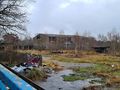
I'd been away from home for a month, travelling, but only had the chance to do a single hash on the way (2021-11-26 43 12 in San Marino (!)), while I'd missed several good hashes back here. I was taking the night bus from Paris back to Hamburg on the 12th and got extremely lucky because the 2021-12-13 hash was less than a kilometre from a train station on my way from Hamburg to my home! So I decided to get this hash on the way, walking there with my big travel backpack, instead of coming back by train and bike later in the day. I also resolved to visit a "Lost Place" near Quickborner Straße, an abandoned factory/warehouse building, that I had been meaning to visit for some time (I really love those places) and that only lay 300 m off my route, meaning a detour of about 1 km.
So I got off at Quickborner Straße and walked to the Lost Place, but found it completely fenced off. I took some photos from the outside and went a short distance further until I got to the Norderstedt industry train track. I searched for an entry to the abandoned building for some time, but continued my way to the hash when I couldn't find any. I walked down An der Koppel, searching for an entry to the field behind it, but couldn't find any. In the end, I braced myself to be shouted at and just walked to the end of a private road, where I fortunately found an entry to the field beyond. To my surprise, it was not agricultural land, but a protected meadow with several paths across. The hash lay 110 m onto the meadow, only 25 m from a path. I got there and took some pictures with Baruch, Jackie & Eagle (who I had to retrieve from the depths of my backpack), then walked to Haslohfurth station, which was the same distance from the hash. My shoulders were quite exhausted when I arrived, having just walked ~5.2 km with my heavy 17-18 kg backpack, and being tired after sleeping badly for two nights in a row and walking lots the past few days. Luckily, the train arrived only a few minutes after I did, taking me home after 29 days of travelling mostly Italy and France.
This was my 49th hash this year – if I want to average one per week, I still have do three more in the two weeks to come. Hoping for some convenient ones, otherwise I might have to drive to some in the days before New Year's …
Photos


coords

proof (technical difficulties)
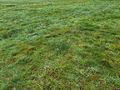
yeah, that's grass

Baruch, Jackie & Eagle (only one sad to go home)

the hashing party
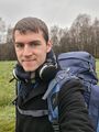
travel selfie at the hash
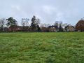
houses over there
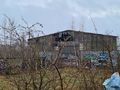
I love Lost Places
no way to get in though …


Achievements
Land geohash, Bicycle geohash, Public transport geohash