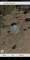
2022-01-23 -37 144

| Sun 23 Jan 2022 in -37,144: -37.6026188, 144.5517225 geohashing.info google osm bing/os kml crox |
Location
In a field near Melton.
Participants
- Felix Dance
- Ruth
Expedition
My girlfriend Ruth and I were heading back from our two-day bushwalk at Mt Buangor, near Beaufort. I had noticed this hash near the route home and when I discovered it would only amount to a 10 minute detour from the most direct route without the geohash I knew we should make a go at it.
As we drove back the stinking hot day encouraged us to stop by Lake Burrumbeet for a swim. While we were there I was almost tempted to suggest a trip down to the -37, 143 geohash, located on a golf course 20 kms to the south. But the approx. 1 hour round trip detour killed off this idea.
Instead, we made our way towards the -37, 144 geohash. We went past the entrance to Lerderderg State Park and along a series of undulating roads, gradually diminishing in importance, until we reached the turnoff to a tree-lined dirt road. I parked up when Ruth had navigated us to the closest approach to the hash and we got out.
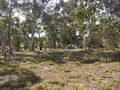
It looked like the hash was just inside the field next to us, with two sets of fences separating it from the road. We walked over to the first fence and it had a complicated configuration of barbed-and-unbarbed wires, maximising the difficulty of getting over it. Nevertheless, I got to the other side. Ruth had a go but found it difficult to avoid getting punctured, and, not as invested in geohashing success as I was, returned to the car.
I strode across No Man's Land between the fences and climbed through the non-barbed second fence. From here I was only a few metres from the hash. I did the hash-dance to get within a metre (right on the fenceline, so clambering through the 2nd fence turned out to be unnecessary), took some photos and returned to the car.
We got celebratory Hungry Jacks vegan rebel whoppers and Warhead slurpies on the way home.
Tracklog
Photos
GPS Proof

Me at the hash
Not-hashing :(
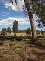
Looking back at the hash


