2022-01-25 -38 146

| Tue 25 Jan 2022 in -38,146: -38.0773553, 146.2396146 geohashing.info google osm bing/os kml crox |
Location
On a dirt track above Bluerock Dam, north of Moe.
Participants
Expedition
A most rewarding hash!
I headed out first thing, the twin goals of beating the heat and getting back in time for work putting me on the road by 7. The fog lay thick over the valley, giving the cattle a ghostly air as they shuffled in and out of view. I knew this road well, Old Sale Road is a popular road-cycling route, and had taken me to three or four hashes before. It's not especially interesting but it gets the job done, and was very quiet this morning. My route was simple - Old Sale Road for a while, then climb up to the ridge, and down the other side to the Blue Rock Dam wall. If I followed that road around it would take me to the hash and I could follow it further to get back on the ridge road (Moe-Willow Grove Rd) and take that back to town.
It was my first time to the dam wall, and as I arrived the fog had almost left the valley, desperate whisps still grasping at the deeper shadows; scattered patches all that remained. The sun had come out and the water to my left shone in vivid blue, the eucalypt canopy below me to my right in brilliant greens and greys. I stopped for a while to enjoy the view before pushing on.
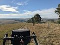
It was not far past the wall that I drew near to the hash. It was in a spectacular location, with wide views across the valley and the dam glinting at its head. No fences to vault, the point was right on the road, I didn't even need to dismount.
And then... oh.
The road that I thought was marked on the map was not a road at all. A private gate, locked. A sign reading "private road, no through road". I consulted the map. I could see now the road didn't join up - but it looked like there was a track on the satellite view.
I thought I'd push on anyway. A low fence was easy to breach, but as I rolled down the track I saw someone at the house off to the side. I turned off and went to say hi.
"Do you mind if I ride through here - I thought there was a through road but the map must be wrong - but it's too far to go back."
"Yeah, go for it, but the road stops just up there."
"Oh really, I thought there was another road that I could get to."
"Nah they never built it."
I was puzzled. I thought for a minute I ought to turn back, but then I thought better of it and pushed on. There was definitely something on the satellite view!
And I'm glad I did. Past the "run down machinery" corner of the farm, with quite a few old vehicles that really would be ok with a lick of paint and some all replacement parts. And then, having climbed a gate or two, out onto the other track that they never built, which was actually quite built, thank you. A vast valley opened itself, and, as if to emphasise the expanse of it all, a wedge-tailed eagle spread her wings and launched herself into the sky before me.
I followed the winding track down the side of the hill, before yet another gate - this one appearing for all the world like a private-property front gate. A garden, house, shed or two on the other side of this fence - but I was pretty sure this was a public road, so I pushed on, weaving between their house, water tank and workshop and over the creek. From here it was a short climb back to Moe-Willow-Grove Rd and a quick jaunt back to town and home.
Tracklog
Photos
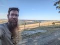
Matt at the hash

GPS Proof
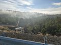
Fog lifts from the valley beneath the dam
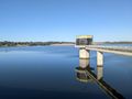
The dam water shines brightly in the morning sun
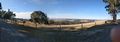
View from the hash - and thumb

$400 o.n.o. No RWC.
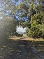
Exiting the copse
The valley opens before me
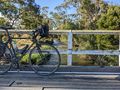
Crossing the creek


Achievements
Matt earned the Bicycle geohash achievement
|