2022-02-18 42 -78
| Fri 18 Feb 2022 in 42,-78: 42.9706876, -78.0014342 geohashing.info google osm bing/os kml crox |
Contents
[hide]Location
Next to BOCES Genesee Valley School in Le Roy
Participants
Expedition
When the hashpoints were published, I took a long hard look at this one because it's in the 90 Centicule and I haven't gotten a hash in this Buffalo section yet. It was quite far away though, so I also wanted to justify the long drive. From the street-views and satellite pictures, I thought this looked like a school and being well after hours, figured I would be able to sneak right in and get the hash right next to the building. I did notice a large gate though so I figured 50/50...I'd also have to be careful about running out of daylight as the sun still sets somewhat early in Feb (around 17:50).
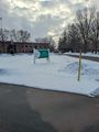
I'm writing this up a bit late and it took me right after writing this sentence to figure out how the heck I was able to get out there. Next Monday was a Holiday (Martin Luther King Day) so we are able to get out a couple hours early from work. Being free at 15:00 (or maybe a little after if a meeting ran over or someone was asking me a question), I got ready to go and grabbed some food for the dogs. I probably left the house around 15:30 and followed my phone GPS to the building. Seeing the gate was open and the Sign indicating this whole complex was related to BOCES, I figured I would be ok entering. I didn't see too many cars in the parking lots and nothing in the lot next to the hash. I parked and hopped out, leaving the dogs in the car. I figured they could wait as I would just be a minute. Walking over using the HashDroid app, I closed in on the hash and got some pictures.
(Looking it up later, BOCES is a public organization that was created by the New York State Legislature in 1948 to provide shared educational programs and services to school districts. You can read more about it here if interested.)
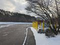
Making my way back to the car, we went next door to the river and a small park where I had also looked up a GeoCache. Here I let the dogs out for a moment to relieve themselves, but with the snowmelt (from the previous days of fluctuating temps) and rushing water, I put them back in the car as the cache was close to the water. However, with the snow still covering a lot of the stone erosion wall next to the road, I figured the cache was most likely still buried and inaccessible. I didn't stick around too long and apparently didn't take any picks of this area.
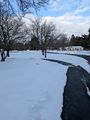
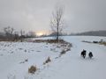
Onto the fun bit, we then headed to Darien Lakes State Park where I've been before to get the dogs a good run and myself a nice hike. The plan was to set the timer for half the time till sunset and end back at the car right around then, but my Girlfriend called to discuss the new house she bought and I recall sitting in the lot for a bit finishing up that call. Losing daylight, I let her know I'd call her back in a bit and we headed out. Probably walked about 45 minutes to an hour, but with the cold wind, it was brisk walking the path between the open fields. At least the wind was at our backs on the way back.
Adventure satiated, I fed the dogs at the car and we headed for home.
Photos
Took this on the way out, but the signage for the BOCES school.
Made it!
View South from the hash area (into the complex).
View North toward where we entered.
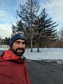
Standard Stupid Grin as I walk back to the car.
Proof for Frozen Hash.
Dog having an absolute blast, running around the State Park.
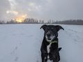
For a few moments, the sun peeking through the clouds and the snow made for some really nice pictures.


Ribbons
This user earned the Land geohash achievement
|
Pedalpusher earned the Frozen Geohash Achievement
|