2022-03-03 51 10
| Thu 3 Mar 2022 in 51,10: 51.2075159, 10.1864440 geohashing.info google osm bing/os kml crox |
Location
In a forest east of Döringsdorf
Participants
Plans
Drive to Döringsdorf near Wanfried by car after work is done and do a nice walk along the so called Kolonnenweg (former border between west and east germany) to the hash, which lays 50 meters north from the border between Thuringia and Hessen.
Expedition
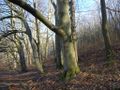
As planned, I drove to Döringsdorf after work and arrived 2:30 pm, parked my car and started to walk along the so called Kolonnenweg - as said, this is the former border between east and west germany and was made by the regime in the eastern part of germany, to have full control about their border.
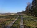
After some 2 km I got near the hash, but I turned out to be above the hash, so I had to get down through some pretty steep terrain to reach the hash, so after the hashdance I took another, much easier way, simply over a meadow, to get on another path. From there, I walked to a nice point with a great panoramic view and then went back to Döringsdorf.
Near the small village, there is this huge cross, the Eichsfelder Kreuz, build in 1980 by people from western Germany, just some 25 meters from the border. Then, since Germany got divided by the wall, people weren't able to pilgrimage to the chapel in Döringsdorf, so they raised this cross as an alternative... Some years later, after the cold war ended, a Chapel of Unity was build as well.
After visiting those two objects, I called it a quit and drove home satisfied...
Personal note: walking along this former border is pretty emotional those days, concerning the current war that Russia is fighting against the Ukraine, not even that far away from here - for it seems that the borders between east and west are being realigned currently and no one can predict how this will end up...
Photos
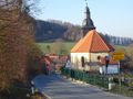
Döringsdorf
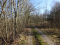
The Kolonnenweg (1)
The Kolonnenweg (2)
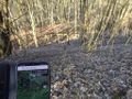
The hash was down there

The hasher at the hash location
Hash surroundings
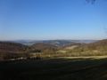
Nice view from the hash
Proof
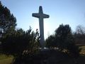
The Eichsfelder Kreuz
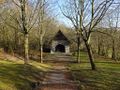
The Chapel of Unity (1)
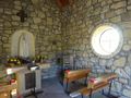
The Chapel of Unity (2)
Former border between west and east Germany


