2022-03-07 -37 144

| Mon 7 Mar 2022 in -37,144: -37.5137339, 144.3886963 geohashing.info google osm bing/os kml crox |
Location
Just off the Lerderderg Track, within the Lerderderg State Park, west of Gisborne
Participants
Expedition
I had seen the location on Saturday morning, and thought that it looked potentially appealing, located as it was within native forest. I didn't give much more thought to it until Monday morning actually arrived though, but then, just after 11am, I looked at it again, and gave serious thought to mounting an expedition. If I caught the 12:14pm Bendigo train from Footscray to Gisborne (about an hour's ride), it was then about 27km from there to the hash. A few hours riding, then a train home and I should be back in time for dinner.
Sounds simple enough, but the main complicating factor was that I wasn't sure how close I would be able to get by bicycle. I was confident I could get within 6.7km, as that was what I had street view images for, and while the last section of the road up to that point was unsealed, it looked in good enough shape for my road bike to handle. The issue was that I had no street view images beyond this point, and if the road from that point on wasn't easily rideable, then 13.4km in and out was a long way to go on foot!
Nevertheless I felt compelled to give it a shot. So I pottered around and got myself ready, including having a bit of an early lunch with my home-baked sourdough (not nearly as good as the last loaves, these weren't strong enough and went quite flat). Before I knew it I was very much in danger of missing the 12:14pm train. I hopped on my bike finally at 12:10, the station still 750m away, with a busy intersection on the way, which, if you're unlucky, can mean a full 2 minute wait for the lights. I whizzed up the road, but I had just missed the lights. I waited for about a minute before I managed to sneak across in a gap in traffic. I arrived at the station at 12:13, but still having to get up over the pedestrian bridge and down to the platform - it was going to come down to the wire. Luckily when I got up onto the bridge, a screen informed me that the Bendigo train was a couple of minutes late. Phew! If I had missed it, the next train wasn't for another hour, and I think I would have abandoned the whole expedition at that point.
The train trip was very straightforward. Arriving at Gisborne I filled up my water bottles, and headed off. Gisborne station is actually located at so-called New Gisborne; Gisborne proper is a few kilometres away down in the valley of Jacksons Creek. Incidentally, Jacksons Creek flows down through Sunbury and the Organ Pipes National Park before joining Deep Creek to form the Maribyrnong River, which eventually makes its way back to Footscray passing just a stone's throw from my house (well, maybe a frisbee's throw, the world record frisbee throw (338m) would cover the required distance but a stone may struggle to get that far).
Down in Gisborne I found a bakery and topped up my earlier early lunch with a generously proportioned spinach and ricotta roll. While eating this, I had a wee keek at the other shops, and noted with interest the Gisborne Ice Cream Co., the third and newest store from the people of the Woodend Ice Cream Co. "Where is the second store?" I hear you ask, but of course it is the Footscray Ice Cream Co.!
Well-fed, I now set off in earnest. The first bit of the ride was not all that pleasant. I was on the Bacchus Marsh road, a single lane each way, with traffic, including the odd truck, doing 100km/h, and mostly without any shoulder. It being early afternoon, the traffic was pretty light, but it was variable how much room cars gave me when passing. Some lovely people got all the way out into the other lane to pass, others would have failed to meet the 1.5m minimum required by law.
When I reached Bullengarook, Google told me I could turn right up Hassed Rd, and take some back roads allegedly only adding a minute to my journey. Given these roads were almost certainly unsealed the whole way, I was sceptical about that time estimate, but it was still a lot more appealing than continuing on the Bacchus Marsh Rd, so I took Google up on its offer. My decision was rewarded almost immediately when I met some friendly cows. There were only a few near me initially, but they did that cow thing where over the course of several minutes every cow in the paddock had slowly gathered to see what the fuss was about. I bid them goodbye and was met with a chorus of moos in return as I set off again. Further along the road I also took a ride-by selfie with a horse.
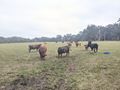
Cows
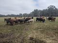
More cows
Cows mooing
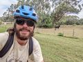
Horse selfie


While this road was definitely slower and bumpier, I had no regrets at all, the landscape was lovely, with crimson rosellas hopping about in the trees. A rubbish truck came down the road at one point though which did kinda spoil the vibe, but I guess people need their bins emptied wherever they live. After a little while I joined Firth Rd, which I would have ended up on if I had persevered along the Bacchus Marsh Rd, and then after another few Ks I reached the point at which I had to leave the realm of street view and enter the park itself.
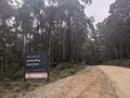
Sign
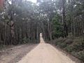
Nice road
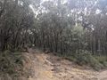
On foot from here
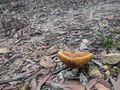
Mushroom


Luckily, O'Briens Rd looked in no worse shape than the road I had been on, so I turned left and kept on riding. This also seemed to be the main access through to the Lerderderg campground from the east, so I was confident that the road was not about to deteriorate significantly. No 13km hike needed today! After a few more Ks I reached the intersection with the Lerderderg track. This was the track that the hashpoint lay but a stone's throw off (a literal stone's throw). I had suspected that this road was not going to be rideable (at least equipped as I was), and indeed it was a lot rougher than what I had been riding along up to this point. Fortunately, by now I was only 2km away from the hash, so a walk in and out from here was now not going to be too arduous.
I locked my bike up to the gate, and continued onwards on foot. The two events of note on my way were spotting a wallaby, and accidentally putting my foot in it (it being a bit of a puddle). Wet left toes notwithstanding, I made rapid progress, even breaking out into a little jog at times, and before I knew it, the hash was only 40m to my right down a little slope, through quite open and easily traversable forest. On my way down, I spotted another macropod of some sort. I didn't get a good look, but I thought this one was maybe a kangaroo. I reached the hash without difficulty, snapped a few pics and got the screengrab of my GPS location.
On my way back up the track to my bike, while appreciating the birds I could see and hear about me (specifically the grey fantails which I was able to identify), I contemplated my return journey. Should I just ride back to Gisborne or try something a little more adventurous? Woodend was only a few kilometres further away, and I found quite appealing the idea of stopping for a drink at the Holgate brewery before hopping on a train home. However, getting there involved crossing the Wombat State forest along roads of unknown quality. But Google was happy to plot me a route, so I was leaning towards giving it a go.
I got back to my bike, and rode back along O'Briens Rd to rejoin Firth Rd. Here was the point at which I was going to need to decide which way to go. Unfortunately the turn off that Google suggested I take did not look suitable for my road bike. There were potentially other ways through but I didn't want to do too much involved navigating. My phone's battery was getting lower, so if it wasn't going to be a simple matter of just following google's directions, I decided I had better take the safer option of just returning to Gisborne.
In the end, for ease of navigating and for a speedier return, I didn't even take the back roads by which I had come, I just continued up Firth Rd leading to a longer ride back along Bacchus Marsh Rd. Nearing 5pm by now, the traffic was heavier which wasn't pleasant, but at least it was almost all downhill in this direction, so I covered the 10km back into Gisborne in only 20 minutes or so. In Gisborne I looked up the train departures on google maps and once again made the mistake of assuming the next departure was one heading into Melbourne. I raced up the hill and got the station just in time, only to discover that the 5:16pm was in fact headed for Bendigo. Silly John.
Fortunately, it was only 10 more minutes until a Melbourne-bound train arrived. This one had come all the way from Swan Hill, and was a limited express, so between Gisborne and Footscray it only stopped once, at Watergardens. I had to put my bike in a separate compartment at the front, and then after settling down in the carriage immediately behind, the conductor came through and told me I was in the first class carriage. Whoops. So I had to move a carriage back. After this, the train trip was uneventful, and I arrived back at Footscray station at 6:13pm, exactly 6 hours after I had arrived on my outbound journey.
I got home a few minutes later, and put on some chickpeas for dinner, having done 173km in total - 117km by rail, 52km by bike, and 4km on foot.
Photos

GPS proof
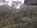
View from hash @-37.5137,144.3887

