2022-04-25 48 7
| Mon 25 Apr 2022 in 48,7: 48.2004389, 7.5606666 geohashing.info google osm bing/os kml crox |
Location
In a field in Hessenheim.
Participants
Plans
This one is surprisingly located. I'm used to municipality boundaries drawing improbable shapes, but I didn't expect the southern neighbourhood of my childhood village of Artolsheim (including the hash point) to actually be part of the neighbouring municipality of Hessenheim.
I will cycle there after work. I expect to reach the coordinates around 18:00.
Expedition
I left home at 17:45 and cycled from Sélestat to Hessenheim. I exited the village, crossed the old Rhône–Rhine Canal and entered the urban area of Artolsheim, without technically leaving the boundaries of Hessenheim.
I followed a farm track along the canal and arrived in front of a cornfield. I left my bicycle there and walked to the coordinates, taking care not to trample the sprouts and muddying my cycling shoes.
After recording proof, I cycled back home.
Photos
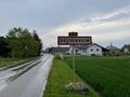
In Hessenheim
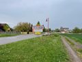
Still technically in Hessenheim
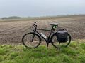
My bicycle near the geohash

Coordinates reached
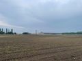
Surroundings
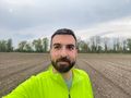
Stupid grin


Achievements
Baarde earned the Land geohash achievement
|
Baarde earned the Bicycle geohash achievement
|