2022-04-26 -37 144
| Tue 26 Apr 2022 in -37,144: -37.7141869, 144.5483611 geohashing.info google osm bing/os kml crox |
Location
Close to Arnolds Creek, just before it joins the Werribee River, Brookfield, Melton
Participants
Plans
I rarely use this section, but things definitely didn't quite go to plan in this case. The plan was to ride to the geohash from my home in Footscray, then get a train back to Footscray from Melton Station.
Expedition
The day after the Wyndham Vale hash, I was having a look around the wiki, and I discovered that the Melbourne West Graticule was now up to 96 co-ordinates successfully reached. Obviously it would be nice to get that up to 100 as quickly as possible. So, when 11:30pm came around and I saw this hash location for the next day I immediately got to thinking about whether I would attempt it, and if so, how I would get there. It looked very doable, located just in some parkland/creek reserve. Apparently it was next to a pistol club, but hopefully not so close that that should prove a problem (slash danger).
It was quite accessible from the station (around 3km), but having done a train both ways expedition for the last one, to do the same again would be a bit boring. I had plans to do other things that next day, but I wanted to ride. I went to sleep pondering my options.
I ended up waking up around 8, and reassessing the situation in the cold hard light of the morning, I decided that if I set off soon enough, and got the train back, I should be able to be home by lunch time, leaving me at least a full afternoon to get other stuff done. It was settled. I ended up leaving at 9:30, once I'd faffed around breakfasting, feeding animals, and getting ready to go, but I was still content with my timing. I packed a few bike tools and a couple of spare tubes. I didn't have my bike lock however, having regrettably managed to leave it at Bridget's house. I could have gone there first to pick it up, but that was not in the right direction and I didn't see why I might want to use it. This was an error.
The ride went smoothly initially, I followed the train line from Footscray to Sunshine, then joined the Kororoit Creek trail. This was pleasant, with a nice range of birds along it. Crossing Ballarat Rd at Deer Park is regrettably a bit of a hassle: the trail ends and you need to use a service lane and a pedestrian crossing to get to the other side, but you can find your way back to the creek via Cairnlea Dr, and paths then recommence along the creek. The creek took me as far as Burnside/Caroline Springs where, after a brief section of being irritated by the amount of traffic on the road google suggested, I ventured into the much more windy (that's windy with a long I) smaller streets. This was much nicer, taking me past little ponds with swamphens, and coots and ducks. It was more navigationally challenging though, and thus much slower, but I eventually got through to the urban frontier.
I immediately knew I was beyond the suburbs as I straightaway passed a yard with a flock of sheep milling about. I continued along the road west, then turned south to cross back over Ballarat Rd, which had now become the Western Freeway. I turned westwards along Greigs Rd, but then disaster struck! Well not quite disaster but, serious annoyance. I felt something go on my back wheel, and my initial thought was, "Ahh a flat tyre, but that's okay I have spare tubes". Alas, this wasn't the problem; I quickly came to a stop and discovered that actually my issue was a broken spoke. Bugger, I lacked three important things to remedy this situation: a spare spoke, a spoke tool, and any experience replacing spokes and trueing wheels.
Still, you can push on with a broken spoke. I loosened the back brake right off so the wheel wouldn't rub against them; the roads were flat anyway so I could get by with just the one brake. But then I discovered that my wheel was so out of alignment that the tyre was actually rubbing up against the bike frame! This was a more annoying issue. While a rim rubbing against a brake pad is a nuisance, it only really wears down the brake pad, which is what it is designed to do. I did not, however, want to unnecessarily wear down the side of my tyre. That could shorten its lifespan considerably.
At this stage though, I had not many other options, so I pushed on regardless, and just had to deal with the significantly elevated amounts of friction that was there, while hoping it wasn't going to wear down my tyre too much. A few kays down the road, I realised I was close to Rockbank station. I realised that it made a good deal of sense to head there, and get a train the rest of the way to Melton. To get there, I had to cross the Bridgefield housing estate that was in quite an early stage of development. The streets and paths were mostly there, including reasonable bike paths, but there were very few actual houses in place yet, which was a bit of a strange experience.
Bridgefield estate
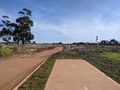
No more path for you!


And then as I neared Rockbank station, even the streets and paths ran out, and all of a sudden I was just following tyre tracks in beautiful bright red soil. It made me really reflect on how housing estates don't spring up out of nowhere. While on the surface they may be soulless depressing landscapes, buried beneath them there is land with a history. The "red calcareous sodic duplex soils", initially covered by open river red gum forest [1], overlooked by the shield volcano Mt Cottrell and the "lava disc" that is Mt Atkinson[2][3] have been well looked after by Indigenous people for tens of thousands of years. Of course, colonials cleared the land and dispossessed the Aboriginal population starting in the early 19th century, well before the 21st century streets of "Bridgefield" were drawn up, but the placing of a housing estate is just the continuation of the colonization process, further disconnecting Indigenous people from the land that is so important to them and central to who they are.
In terms of which particular Indigenous people it's hard to be too sure. From my research it seems that the area around Rockbank has been contested in recent times in terms of which groups are the custodians. To the north and east lies the lands of the Wurundjeri-Woiwurrung, to the south is Bunurong country, while to the west it's where the Wadawurrung live. According to the new boundaries agreed to and coming into effect last year[4], Rockbank is just within the Wurundjeri-Woiwurrung area, but that doesn't necessarily mean that it's always been unambiguously the Wurundjeri-Woiwurrung whose land this was. A 2021 boundary agreement clearly doesn't determine the history of the land, as much as the known history of the land would have played into the recent agreement. In any case, if you read the full proposal for the new boundaries attached at the page linked above, you find it says at one point:
In 1835, neither the Bunurong nor the Wurundjeri Woi Wurrung Peoples conceived boundaries as fixed lines on a map. Boundaries between both groups and individual clan estates resembled differing areas of exclusive and shared control separated by boundary corridors, as opposed to firm borders.
And on top of this, even if we were sure that the 2021 boundaries precisely reflected the situation pre-invasion, we shouldn't project this situation indefinitely back into the past. It seems unarguable that there wouldn't have been significant changes to the socio-political landscape over the millennia that have passed since humans first arrived in the region, at least as far back as 40,000 years ago[5]. Just look at how much other parts of the world have changed in just a few thousand years! But for a specific example, the Pama-Nyungan languages spoken by the people of the Kulin Nation only arrived in this part of the continent 5000 to 7000 years ago[6]. The advent of these languages must surely have coincided with significant cultural upheaval, and when you look at how much the physical landscape has changed since the peak of the last ice age with the flooding of Bass Strait, and subsequent flooding of Port Phillip Bay, it's hard to imagine that there weren't socio-political changes alongside these massive geological changes. Put simply, it's hard to say who exactly has been caring for the land for all of the tens of thousands of years that it has been occupied, but in more recent times we can at least say that it was people of the Kulin Nation who lived here, even if it's a bit ambiguous in terms of which particular language group: Woiwurrung, Bunurong or Wadawurrung.
Anyway, to get back to my expedition, I reached Rockbank station and there was a train in only about 7 minutes' time. I checked my tyre and discovered that in the 5km or so that it had been rubbing, there was already very noticeable wearing. Not ideal. So when I got to Melton station, I wanted to avoid riding another 6km on it to the hash and back. If only I could lock it up at the station, and head down on foot. But alas, I had no lock. I was very tempted to just leave it at a bike rack and hope that it would survive. It wasn't going to draw much attention to itself that way, and surely the chance that dedicated bike thieves would come by right in the next hour was pretty insignificant.
However, at the bike rack that I sussed out, there were at least half a dozen un-bicycled locks sitting there. This convinced me that bicycle thievery was enough of a problem here that I didn't want to risk it. Though now I'm wondering how a lock comes to be still locked to the rack without a bike attached. Did the bicycle owner just fail to enloop their bike in the lock while attempting to secure it? It's something I have done before, though thankfully my bike survived the experience.
I had to move on towards the hash while still burdened with my bike. I thought I might be able stash it away somewhere on the way if a suitable hiding spot presented itself, but I thought it was likely that I was going to have to take it the whole way and back, and this did indeed prove to be the case. I could walk my bike in the usual manner, but the problem with this was that I still had to deal with the rubbing. I wasn't convinced this was any better than riding it in terms of reducing the wear on the tyre. and the slightest bump or bit of gravel on the path would mean the tyre lost traction with the ground, the excess friction would win out, and the wheel would start dragging rather than spinning.
I tried walking it while lifting the back wheel from the ground, but this was very awkward and difficult to steer, and the lifting arm got tired rapidly. In the end, the best solution I found was just to hoist the whole bike over my shoulder and carry it. Thankfully my bike is fairly light, around 10kg, so while it was still awkward it was manageable. With my bike in place, I even managed to jog a bit to hurry things along.
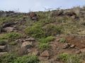
I followed the path along Arnolds creek, which started out more pleasantly vegetated, and with more recent planting out in sections promising even nicer vegetation in future. However as I got further along, the creek reserve appeared more and more unloved. By the time I got to the vicinity of the hash, it was a weedy grassy rocky landscape. The path had followed the edge of the housing on the south east side, meanwhile the creek valley had got wider and deeper. By the time I had to leave the path to go 30m or so into the reserve towards the creek, a steep slope had developed.
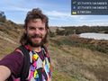
I left my bike at the top, and clambered down the rocky weedy slope past a large woody spiky shrub. I got the app to light up green without much difficulty, and I surveyed the scene. The pistol club was clearly an indoor facility, to the outside just looking like a large shed. I heard some clicking noises which I thought for a moment might have been the sound of something firing, but then I decided it was actually the sound of a frog down by the creek.
I climbed back up to my bike, and walked/jogged back towards the station. Along the way I managed to do a full kilometre of jogging with my bike upon my back, in a time according to strava of 6 minutes 54 seconds. Towards the end my carrying arm was getting rather sore, so I reverted back to walking/dragging my bike for the last section. I got back to Melton station in time for the 1:10pm train, and I was back in Footscray before 2.
I went straight to the Inner West Community Bike Hub, where they sold me a whole new (second hand) wheel and tyre, which meant that I probably could have worn the tyre down a bit more in the end by riding on it, but oh well. They told me it would be probably be ready to be picked up that afternoon, which was a pleasant surprise. I walked home via Nhu Lan for a banh mi, and at about 4:30 I got the text saying I could pick up my bike, so I walked down to pick it up, bringing a satisfying sense of closure to my expedition. Is an expedition really finished until your bike gets home too? I don't think so.
Photos
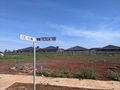
I may be at Hinkler Crescent, possibly
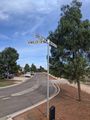
Success! @-37.7142,144.5484
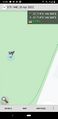
GPS
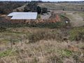
The pistol club
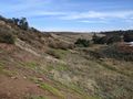
Slopey
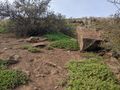
Shrubby rocky dusty weedy
The way back up to my bike
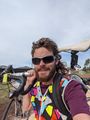
Jogging with bike


Footnotes
- Jump up ↑ http://vro.agriculture.vic.gov.au/dpi/vro/portregn.nsf/pages/port_land_systems_nth_melb_pdf/$file/north%20of%20melbourne%20-%20ch6.pdf
- Jump up ↑ http://www.geocities.ws/alhy731/volcanoes/type.html
- Jump up ↑ http://vro.agriculture.vic.gov.au/dpi/vro/portregn.nsf/pages/pp_eruption-points-melbourne-map
- Jump up ↑ https://www.aboriginalheritagecouncil.vic.gov.au/boundary-variations-consideration-june-2021
- Jump up ↑ https://en.wikipedia.org/wiki/Aboriginal_Victorians
- Jump up ↑ https://pamanyungan.compevol.auckland.ac.nz/what-we-found/