2022-05-13 42 -78
| Fri 13 May 2022 in 42,-78: 42.0401106, -78.8103403 geohashing.info google osm bing/os kml crox |
Location
Allegany State Park, near the Bear Springs trail
Participants
- Pedalpusher
- Simon the dog
- Myka the dog
Expedition
The original plan for this evening was to go for a bike ride as I haven't been able to get out for a while. However, when I saw the hashpoints for this weekend, the plans immediately changed. Initially thought this hash was just randomly in the woods not near anything, but comparing the map to the park map, I found this was actually pretty close to the Bear Springs trail which is just a very short (0.5 Mile/ not quite 1 KM) hike to a spring with some old foundations and a half-dome over the spring outlet to make a little pool inside. There is an old trail foundation that goes beyond the spring, but it's not an official trail and I've never seen where it goes before. I was thinking this would be a good opportunity to see, especially if it curls around and eventually heads toward the hash.
After work, I got the dogs ready, had a quick meal of leftovers and we headed to ASP. Arriving with no issues, the dogs hopped out of the car eager to explore as always. Heading down the trail, I turned on my GPS to get it warmed up as sometimes it takes a while to pick up enough satellites in Allegany. Fortunately, I did that because it wasn't until right before getting to the spring that it started mapping my location. We were still about a half mile away but I was now following the old trail. It seems to be on a leveled narrow area so I'm thinking it's possibly a very old trainbed. As I was walking, I think it curled a little bit in my direction, but not much. By the time the trail just kind of disappeared, I was now about 0.6 Miles (1 KM) away from the hash. Following the GPS, it seemed to take longer than expected to weave my way through the woods and over a couple creeks before hitting the incline near the hash.
Eventually, I tracked it down and was able to get a good reading and a couple pictures before heading back. Now here is where I got a little confused and because I curled around a little, the map in my head from where I started was a little disoriented. Initially thinking I was cutting across the valley back to the spring, I ended up retracing my steps for a while before thinking I REALLY should have put in either the spring or the car into a saved location...Note for next time!
I then had a better idea of zooming out on the GPS map so I could kind of aim myself toward where the tracklog started. However, when I zoomed out, I didn't realize it took a second to load the fringe of the map, so for a time, I was still walking further north than I should have. Upon seeing my current tracks overlaying and crisscrossing the way in, I realized I needed to zoom out more and change direction a bit. I don't know if I was tired or just moving more slowly than normal, but it seemed to take a while to get that half mile distance from the hash so I could start expecting the trail 'any moment now'. After another small readjustment, Simon suddenly changed direction as we were going up a small ridge, and I knew that had to be the trail. Sure enough, we were back on track and heading for the car.
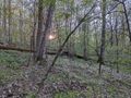
All in all, it was a nice hike among the spring flowers and the newly leafed trees.
Photos
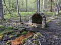
Getting to the end of the trail, we have Bear Springs.
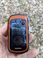
Made it!
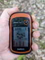
Accuracy.

Hash-Dogs perked up at the hash.
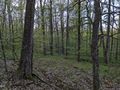
View West from the hash.
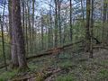
View North.
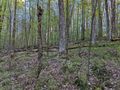
View East.
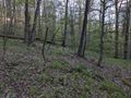
View South.

Standard Stupid Grin.
View of the hash as we were leaving.
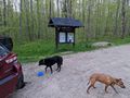
The dogs finishing up their dinner at the trailhead.


Ribbons
This user earned the Land geohash achievement
|