2022-05-26 42 -78
| Thu 26 May 2022 in 42,-78: 42.6728304, -78.3787997 geohashing.info google osm bing/os kml crox |
Contents
[hide]Location
Beaver Meadow Audubon Center, right on a trail
Participants
Expedition
Looking at the satellite pictures, I immediately thought this was a swampy area and inaccessibly private lands, but then I thought I recognized the layout of the ponds and thought this was pretty close to Beaver Meadow so I looked at the OpenStreetMap view and saw this was definitely public land! The map must have been updated between Hash-day and writing the report up a couple weeks later because I didn't see a trail going all the way out to the hash. Being a Nature Preserve, I wasn't sure I wanted to tromp through the woods off-trail, but looking at one of their maps, it appeared a trail should run by, pretty close. This said that maybe the hash-woods might not be as swampy as the aerial view might initially suggest. On a whim, I then checked the 'Nearby Geocaches' button on the Geohashing.info site and found a Hash Collision event! Now I'm going for sure. The cache page said it was just 20 feet(7 meters) off the trail so the hash must also be within 50 feet (15 meters). I can definitely make this and comfortable taking a few steps off the trail for this.
After work, I fed the dogs but had to leave them home since they aren't allowed here. I had a pretty good idea how to navigate my way out there as it was close to a Summer Camp I used to work at, plus a family friend's property. Getting to Strikersville, I turned on my phone's GPS just in case I missed the turn, but didn't have to worry. I found my way to the Audubon Center and then continued up the road to the hash-woods. I knew, from looking at the satellite pictures, there was a railroad that went by and definitely had a spot to pull off the road. I was so intent on parking there, I kept driving after noting the trailhead where I needed to go. It was only after going past a flat area where I could have pulled off that I realized I could have parked closer, but now I didn't want to turn around a couple times. Whatever, I could walk the extra little bit on the road.
Walking back to the trailhead, I turned on the GPS to get it warmed up and headed into the woods, following the signs for the Bracken Trail and Vireo Woods trail, not entirely sure which one I wanted. I knew the direction I wanted to go through and getting to the split, I took the Bracken Trail toward the pond. There was a shelter with a map on the wall, so I checked that out for a moment before picking up the trail again. There were a couple branches of the trail that could be taken as shortcuts to the other side, but I had the time to explore so I was going all the way around. I did note at one of these, that there was another shelter at the top of a small hill, but declined to go up the incline to the Tulip Summit.
Working my way around the trail, I could see the pond, but wasn't too close, although there was another trail branch going to the edge of the pond at one point. Getting close to the hash-area, I was shocked as the distance to the hash drop nearly to 0 without even having to step off the trail. Going back and forth on the trail, I was able to get a good reading and my pictures without even having to step into the woods. As I was searching for the exact spot, I heard a huff in the woods and paused in my mini-GPS dance. Through the trees I saw a White-Tail deer bound away after snorting at me a couple more times.
Now for that Geocache...flipping the GPS to the cache location, I saw (and expected) the distance to be about 20 feet which it started out being, but then dropped down to about 9 feet (3 meters). That's weird, but knowing it was about 20 feet off the trail from the hash based on my initial research, I saw two trees that were down in the woods a short distance away. That seemed like a good candidate for the Cache area, but exploring those trees, I came up empty. Maybe I entered the coordinates wrong or the map wasn't right? Back to the Hash and again the distance fell to minimal. Huh...there's this other dead tree laying just off the trail. Oh, hey! Hash Collision successful!
After signing the logbook, I continued exploring the trail and found the other side of the Vireo Woods trail at the same place the Tulip Summit path came back down. I decided to check out the shelter and on the way up, I found a Wood Frog which was cool. Rather than cut back toward where I came from, I backtracked down the hill and explored the Vireo Woods trail, knowing it would dump me back on the trail I started on. Shortly after branching off, I heard the deer snorting at me again, and saw another flick of the tail through the trees.
I had a great adventure and decided to stop for dinner at a new brewery on the way home in Orchard Park. It wasn't bad, but the food was only 'ok' and they didn't have a large beer selection so only mixed reviews here. At least I got to see some Playoff (Ice) Hockey while I ate.
Photos
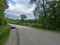
Taken on the way back, but a view of where I parked.
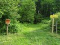
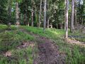
Walking up to the trailhead.
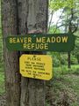
A little bit into the woods, a sign for the Refuge and some standard rules to follow.
Made it!
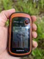
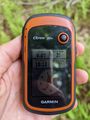
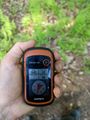
Accuracy.
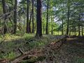
View East from the Hash.
View South (and unknowingly at the time, toward the Cache).
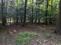
View West, toward the pond.
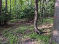
View North, and where I thought the direction of cache was.

Standard Stupid Grin.
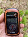
Distance to the Cache, but it didn't make sense at the time.
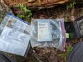
Eventually found the cache for a Hash Collision event!
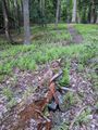
View of the Cache AND Hash on the trail just a few feet apart!
Distance at the cache, back to the Hash which kinda matches up.
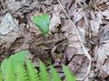
The Wood Frog next to the trail. They really blend in!
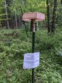
Toward the end of the Vireo Woods trail, I found that the University of Oklahoma was doing some kind of Biological Study and saw a couple of these in the woods.


Ribbons
This user earned the Land geohash achievement
|
Pedalpusher earned the Hash collision achievement
|