2022-05-28 -37 144
| Sat 28 May 2022 in -37,144: -37.8148194, 144.8469525 geohashing.info google osm bing/os kml crox |
Location
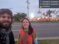
On a footpath in an industrial area in Brooklyn.
Participants
- John
- Bridget
Expedition
At around 5pm we were on our way back from having been for a drive out to Mt Macedon, where we'd been for a little walk to take in some fresh air, and see some nature. We saw a eastern yellow robin, and several kinds of fungus, which were the highlights from the nature side of things.
In our geohashing chat it had been noted that the hash for today was pretty easily accessible in Brooklyn, but no-one had seemingly had the time or inclination to visit it up until that point. So we decided that we had better make a detour there on our way home, probably only adding about 15-20mins to our trip.
We got off the Calder Fwy in Keilor, passed Keilor cemetery, and got onto the Western Ring Rd. After a little stretch of this we then got onto Geelong Rd heading back towards the city. We turned left onto McDonald Rd, which was where the hash lay, and after a moment we were there. We overshot slightly to pull into the driveway of the Veolia Environmental Services plant. This was as expected, deserted at this time on a weekend, so we weren't getting in anyone's way to park here for a moment.
We got out, and got to the hash in the briefest of moments. It was, as expected from the satellite image, just on the footpath. Easy Peasy. We snapped a pic, making sure to get the cherry pickers in the background, which are also known as, as I found out thanks to Felix, Elevating Work Platforms, or EWPs for short.
Then we were on our way again, with darkness falling around us. We got back onto Geelong Rd, and after passing another cemetery, the Footscray General Cemetery, we got home about 15mins later.
Photos
Made it! @-37.8148,144.8470

GPS proof

