2022-07-01 45 -121
| Fri 1 Jul 2022 in 45,-121: 45.4121743, -121.5708523 geohashing.info google osm bing/os kml crox |
Location
On the shoulder of Oregon Highway 35, by the East Fork Hood River.
Participants
- Michael5000
- Mrs.5000
- Jennifer
- Brian
Expedition
After an initial failure at 2022-07-01 45 -122, the 5000s continued eastward up towards Mt. Hood to where Jennifer and Brian are staying, in the Welches area. There was some lolling about and consumption of baked goods, after which the expedition set off in force!
There's not much to tell. We enjoyed spectacular views on Mt. Hood from US 26, then, even more spectacular views of Mt. Hood from Oregon 35, and then there was a convenient place to turn off and we stood on the hashpoint, and it was terrific!
Afterwards, we went on a more conventional light hike from a nearby trailhead, and later there was some pizza, and finally the 5000s headed back to town and took care of business at 2022-07-01 45 -122.
Photos

In the forthcoming Geohashing movie, Michael5000 will be played by Christopher Walken.
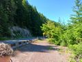
Looking north!

Looking south!
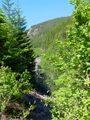
Looking down at the river from near the hashpoint.

A little hashpoint mountain flower.
The hashpoint SOUNDED great!


