2022-07-07 42 -78
| Thu 7 Jul 2022 in 42,-78: 42.9435557, -78.5528303 geohashing.info google osm bing/os kml crox |
Location
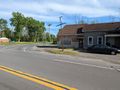
Corner of Genesee St and Wende Rd in Millgrove
Participants
Expedition
This Geohash landed right on the edge of the road at an intersection and not too far away from Darien Lakes State Park. Plus, still needing the 95th centicule, this would get me one step closer to completing my map. I did take the dogs out to the park at lunch, which is why Myka probably didn't want to come with us in the evening. She is content to sleep on the couch now while Simon goes on adventures with me.
Driving out to the hash, I didn't run into any issues, but did turn on the Phone GPS about 10 minutes out so I wouldn't miss my turn. I was planning on parking in the pull-off right next to the hash, but when I got to the corner, I could see a car already there. Looking at the street-view earlier, it did look like a house, but I wasn't sure if it was occupied. Guess it was, so instead, I parked across the street at a restaurant called the Lunchbox. I almost, again, had a drink with the Geohash, but as the name suggests, they are only open around lunchtime.
Being a busier road, I didn't want to bring Simon along, just to hop back in the car, so I just carefully crossed Genesee/Route 33 to the hash and got a couple quick pictures. I'm sure the cars passing by were all wondering what I was taking pictures of. Satisfied with the results, I made my way back to the car and dropped a pin on the map for the parking area I normally go to at Darien Lakes State Park. As we were driving, we were passing the northern side of the park and I recognized the parking area that I've walked to from the other side. Thinking it dumb to drive all the way around the block, I turned around and parked here instead. Plus, this would be better for Simon on this warm day to play in the creek that we would be walking next to. With plenty of daylight left, I set my alarm for 45 minutes and we headed off on the Orange Trail. Coming from this side, I didn't realize the lean-to was so close, but I've also never explored the red trail that crosses close to there so we headed that way to see if we could find the trailhead. The red trail was much more interesting and diverse than the orange trail so I'm glad we went, but my alarm went off before we got to a terminus.
Heading back to the car, I fed Simon before we drove home. A nice adventure indeed!
Note: I want to watch this date for a potential Last Man Standing. The Washington State reports look like they are accidental dates for a multi-hash the previous day.
Photos
Made it!
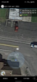
View East from the Hash.
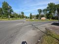
View West.
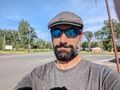
Really Stupid Grin today...
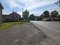
On the way back to the car, a view of the Hash.
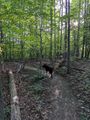
Hiking at Darien Lakes afterwords.


Ribbons
This user earned the Land geohash achievement
|
Expeditions and Plans
| 2022-07-07 | ||
|---|---|---|
| Buffalo, New York | Pedalpusher | Corner of Genesee St and Wende Rd in Millgrove |
| Tri Cities, Washington | Someone went | located on a field near Royal City. |
| Mt. St. Helens, Washington | Someone went | located next between a road and train tracks in McKenna. |
| Snoqualmie, Washington | Someone went | located in a forest near Boulder Lake. |
| Seattle, Washington | Someone went | located in Puget Sound off the coast of Hansville. |