2022-07-16 48 -118
| Sat 16 Jul 2022 in Kettle Falls: 48.9917831, -118.2057052 geohashing.info google osm bing/os kml crox |
Location
Farmland in Laurier, WA, near the Canada border.
Participants
Plans
Stop by (more or less) on the way home from a camping trip
Expedition
This is the most reasonable point I've seen in Kettle Falls in years, though it was still snugged up to the border. Based on the satellite view, this would be very easy to achieve also. More on that lower down...
The border is super accessible here - only a barbed wire fence. No, I did not dance across it - but I absolutely would have if the geohashpoint had been located right there. After snapping these photos, I headed towards the farmer.
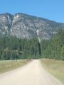
First approach showed the point to be somewhat close to the road, so I drove that road up a steep hillside above the farm. Barbed wire fence separates me from the point. No signs forbidding entry, but best to continue with my original plan.
I saw the farmer out in the field, so drive in and waved a hand. They came over and I introduced myself, explaining I just came from camping in Northport and a very basic rendition of what geohashing was. The lady of the land was a bit concerned that more of us would appear over the hills to descend on their land, but other than 5k, I thought that was unlikely and said so. Had this been in the city, yes - more of us would meet up.
When I explained my camping location and we compared notes, it turns out the farmer had cattle over on the Phillips' ranch, right next to the property where I spent the week. Practically neighbors now, they waved me on to the field with these words. "Let us know if you find gold there - oh, and let us know if you find a cougar there also."
Slightly wary, I set off to explore the field. GPS said I needed to go further east, into the brush, and I took one quick expedition there. Overhead view showed it to be near the metal pipe, still sitting in the same location in the field. I crossed those points and more, but never got a truly close reading on the GPS. Maybe all that gold throws the readings off...
Also in the "GPS weirdness" bucket, I took two photos from different locations, one from up in the field looking towards the house of the owners - and both received the same coordinates, north of the border (49.0178,-118.2269 - more than 2 miles away as the crow flies). I believe I selected "choose the point of the photo" on geohashdroid - and indeed, the photo shows that coordinate today on my phone. Conspiracy? Map/border weirdness? I wish I had chosen "use my current coords" instead.
Anyhow, point achieved, I returned to the car. Giving a friendly wave, I drove along the border again and made my way back to Seattle. I did stop and shoot straight west along the border, showing "The Slash" - more about that here.
Tracklog
(what would a tracklog have looked like?!?)
Photos
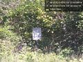
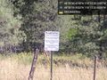
Border sign @48.9999,-118.2172
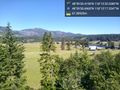
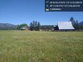
Up the hill @48.9919,-118.2048
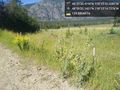
Fence @48.9923,-118.2041
Trail @49.0178,-118.2269
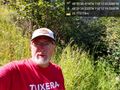
Geohasher @48.9917,-118.2054
Ambassador @49.0178,-118.2269
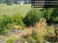
Above again @48.9914,-118.2056
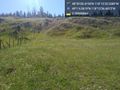
Border again @49.0000,-118.2091
Border west


Achievements
Thomcat earned the Graticule Unlocked Achievement
|
Thomcat earned the Ambassador achievement
|