2022-07-29 42 -78
| Fri 29 Jul 2022 in 42,-78: 42.6199062, -78.9212394 geohashing.info google osm bing/os kml crox |
Location
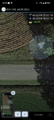
Just off Sandrock Rd and next to a field in Eden
Participants
Expedition
I was really hoping that a hash would land in Allegany State Park, but I really didn't expect much this weekend. However, I saw this might be reachable even if it was posted and it was on Friday so I could hit it on the way down to Allegany. You see, I was planning on a long weekend backpacking trip to complete the Southern Half of the North Country Trail that goes through ASP. I had already taken off Thursday to get things ready and Friday I would drive down and start my hike in to the lean-to closest to Pennsylvania and stay 2 nights there.
It was a lazy morning as I didn't have a ton to get together and I didn't want to worry about packing an additional lunch so I was going to start my drive after I ate. Getting a couple extra things, I ended up getting distracted and forgot to grab my toiletry bag and the bug spray sitting on the table. It would have been nice to take a shower before driving home, but oh well. I didn't remember until I was actually on the trail so there was no going back. I'm getting a little ahead of myself, but the drive to the hash would be slightly out of the way, but would not add too much time to my drive. I followed my Phone GPS to the hash and about half way there, my Girlfriend called so I was happy to talk to her as I knew I wouldn't have any signal for the weekend.
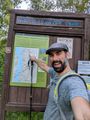
I was able to get to the hash without trouble and with perfect timing as she had to go for a meeting. I was able to park across the road from the hash and was happy to see it wasn't posted at all. I used the HashDroid app and was able to get a good reading without having to go into the thick brush between the road and the field. Got a couple pictures and continued on my way.
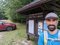
I got to Allegany around 14:00 and stopped at the Admin building to let the Park Police know I would be parking at the trailhead and be in the woods for a couple days. I also got an updated bear report (some activity, but more toward the campgrounds and not so much where I would be), filled up my water bottles and drove up to the Eastwood Meadows trailhead. There's a nice big parking area there and the NCT actually connects to that trail real close so I wouldn't have to walk on the road at all.
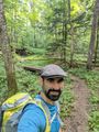
Day 1 was really nice for an estimated 7.5 Mi/12 KM (so was the whole weekend with temps in the mid-70s/25C and lows in the mid-50s/13C) and I took it slow as I had to get used to the pack on my back. Weighting it at home, it was about 25 pounds/11kg so not too bad, but my shoulders were not prepared for it so they were a little sore just a half hour in. I made some adjustments and it was a little better. Stopped a couple times for some snacks and to rest, and saw a deer not too far off the trail at one point. Getting down to ASP Rt 3, I stopped to fill up my water from the creek. The filter was still new so I fumbled around with that for longer than I should have, but I got better as the trip went on. I eventually made it to my lean-to right around 17:00 and was happy to see I likely wasn't going to have to share for the night. I set up camp and pulled out my smoked polish sausage for dinner (it started in my pack somewhat insulated and frozen) and was happy to feel it was still cool. First night was rough, being in a new place and the mice running all around in the walls of the lean-to. I even had one try crawling up my sleeping bag but that guy got unceremoniously tossed off as I flicked my elbow under the covers. Got up to pee right around 03:00 and felt a couple drops as I was stepping back into the shelter. Moments later, it was POURING out there; couldn't have timed that better.
Day 2 started out early but still slow as I thought it was still sprinkling, but it just turned out the water was still dripping off the trees. I started my hike to the PA border (about another 7 miles) around 08:00 and decided to leave my sleeping gear at the lean-to to lighten my load (and I would be coming back anyway). The 3-5 pounds made a HUGE difference and I was able to move a lot easier. The hike started up again, but I turned off Airplane Mode on my phone when I got to the top and found I did have a decent signal, so I paused and texted my gf to let her know how things were going and I'd try to call on my way back in the afternoon. It was a beautiful hike and was really excited to make it to the PA/NY border. But that's in the middle of the woods so I continued the additional mile to the trailhead at PA Rt 346. Got there around 11:00 and had a snack before heading back. Around 12:30, I rehydrated a smoked 3 bean chili, but used cold water (didn't want to cart around additional equipment like a burner/fuel) and figured it would take a while to get ready. Plus, the swaying in my pack might stir it up a little and help too. I stopped about a half hour later to check on it and add a little more water for the right consistency to make a burrito with it. The corn and some of the beef was still crunchy so I figured another half hour would be good. Right around that time, I made it back to another trail meetup and decided to have my lunch at the Firetower which should be just up the trail. It was going up more than I would have liked after 12 miles, but I knew it was close. Fortunately, I found it and sat down to enjoy my rehydrated meal and rest for a bit. Called my gf and even though I just had 2 bars, was able to have a clean connection and chatted for a bit. It was great being able to talk to her before I headed back to the lean-to in the valley. I got back around 15:00 but was so exhausted and my feet sore that I just layed on my bedding and read on my e-reader until dinnertime and then read some more until I was ready for bed. The mice had another evening of Olympics running around again, but the Climb-the-Camper event was cancelled after the previous evening's incident. I still didn't sleep great, but it was a lot better than the first night.
Day 3 I just needed to pack up my stuff and head back. I did see some fresh bear droppings on the trail, but it was far enough from the lean-to that I wasn't worried retroactively (I also had my food sealed and hung in a tree). I made it back to the car and was happy my hike was over.
It was a fantastic adventure and I estimate I hiked about 30+ miles/50 KM. I even got in a Geohash on the way! I really wish I had checked the surrounding hashes for the weekend before I left, because on Sunday, there was a Holy Hash in the Dunkirk Graticule that I definitely would have gone to, but alas, I was unawares. It would have been an extra long drive home and I was pretty tired, but that would have been cool to get.
It looks like this may also be a Last Man Standing. The other Expedition posted for today was a planning mission, but looks like they ran out of time and never went. Will give it some time before I claim the ribbon.
Photos
Made it!
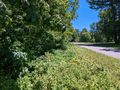
View East and down the road.
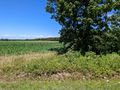
View North and into the field.
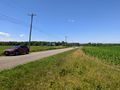
View West from where I drove in.
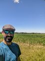
Standard Stupid Grin.
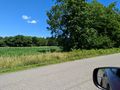
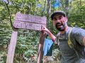
Before driving to ASP, a view of the hash.
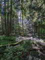
Highlights of my Backpacking trip, this is a nice area where the trail crosses a couple streams.
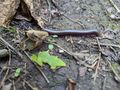
The millipedes were out in force!
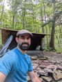
Made it to the shelter that would be my home for two nights.
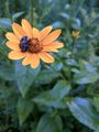
This solo bee was cuddled up to this flower to get through the overnight cold and rain. Hadn't quite warmed up enough yet.
After stopping to refill my water from the creek, I turned the corner of the trail to see this beautiful sight.
I'm pretty excited to make it to my goal of the PA/NY border (even though I forgot to get this shot when I first got there. This was actually on the way back).
Made it to the trailhead at PA Rt 346.

On the way back, the bee was gone, but I found this female Goldenrod Crab Spider waiting for lunch.
Made it back to the car after a really awesome weekend!


Ribbons
This user earned the Land geohash achievement
|
Expeditions and Plans
| 2022-07-29 | ||
|---|---|---|
| Lynn, Massachusetts | Someone went | In a swamp next to the Salem Beverly Waterway Canal, near Topsfield, MA. |
| Buffalo, New York | Pedalpusher | Just off Sandrock Rd and next to a field in Eden |