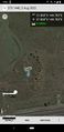
2022-08-02 -37 144

| Tue 2 Aug 2022 in -37,144: -37.8601772, 144.7834596 geohashing.info google osm bing/os kml crox |
Location
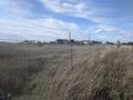
In some long grass next to the "Melbourne Ball Park" baseball field in Laverton
Participants
Plans
My plan was to ride the 20km or so to the geohash.
Expedition
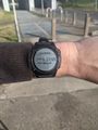
Seeing the location for the hash late the night before, I was immediately keen. Part of my keenness was the fact that I could use the Federation trail, which I had used on my way to my third ever (and first solo) geohash in 2013. Another reason to be keen was to use the GPS capacity of my new watch for the first time.
I set off from Ascot Vale after lunch. I headed down the stock route, along the river for a bit, across Footscray, followed the train line past Seddon and Yarraville stations, and then went South West across Yarraville to Fogarty avenue.
Here, according to google maps, the Federation trail was to begin. In 2013 I had joined it further along at Geelong Rd. But here there was no sign of it. The Newport-Sunshine railway line that I was supposed to cross was impassable. As I stared at my phone trying to work out what was going on, another cyclist rolled up looking equally confused. We compared notes: Google does say there is a path here, but there clearly isn't. Hmmm. We agreed that the obvious solution was to head north and use Francis St instead. So I retreated northwards, going across McIvor Reserve where I had played many a game of junior cricket in my youth.
Francis St was unpleasant, with truck traffic and no bike lane, but it got me up to Geelong Rd, which I could follow using service lanes until it met the Federation trail. So in the end, I joined the trail at the same point that I had in 2013.
The trail takes you through some quite industrial parts of Melbourne's west. Much like in 2013, it was still smelly in parts. I passed old factories, warehouses and an enormous yard filled with countless new trucks all neatly lined up. Looking at google maps now, I apparently went very close to the infamous Cedar Meats facility, site of one of Melbourne's earliest covid outbreaks.
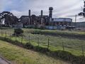
Industry
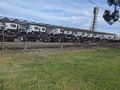
A swarm of trucks


In 2013, I was forced to divert from the Federation trail at Fitzgerald Rd, due to the closure of the following section. On this day the trail appeared to continue on as intended, but it was here at Fitzgerald Rd that I actually needed to leave the trail, to head south. But as it turns out, if I had wanted to continue onwards, I only would have made it another couple of kays, before reaching another section of closed trail, as I discovered when researching the missing start of the Federation Trail in Yarraville. The answer to that question, is that it relates to the Westgate Tunnel Project. All in all, my experience of the Federation trail, across two expeditions, nine years apart, is not positive.
Fortunately, things improved from here. Heading south on Fitzgerald Rd was still far from ideal with traffic doing up to 80kph, but at least they had put in bike lanes since last time, even if they were the type that have a tendency to disappear when approaching intersections. After crossing Leakes Rd, I very briefly joined Old Geelong Rd before I turned left to join a quiet side street and leave the ugly world of traffic behind (though I was now running parallel to the Princes Fwy).
I also now had a strong northerly right behind me, so I hooned along the bitumen, my new watch telling my I was pushing 50kph at my fastest. Reaching the Werribee train line, I turned left to underpass the freeway, and emerging on the other side, the environs of the hash was laid out before me.

I followed the bike path down to Merton St, where I found a lovely old bluestone railway bridge/road ford which my research tells me was built in 1859 (I assume with convict labour) to cross the Laverton Creek. These days the creek has had a channel dug for it under the road, but it apparently very commonly floods, and indeed, the google streetview image shows it in a state of modest flooding.

I was still 400 odd metres from the hash, and a potential problem now presented itself. It hadn't occurred to me that there might not be public access to the baseball field, and yet I was now confronted with barbed wire. As I now know, this was not just any old baseball field, this was according to austadiums.com "Victoria's premier baseball stadium". It occurred to me that, had there been a game on, I could have got the admit one achievement, but it was clear from the fact that there was literally no-one around, that there was no game on. A Tuesday afternoon would seem like an unlikely time to schedule a game anyway.
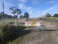
All was not lost, however. The hash was not within the stadium itself, but on the other side. Perhaps the hash lay outside the fenced area. Staying on this side of the fence, I could follow a dirt track that ran alongside the railway line. There was a gate at the beginning of the track telling me that only authorized personnel were permitted beyond that point, that surveillance cameras were in use and that trespassers would be prosecuted, but I paid no heed to these warnings. The place was deserted and it wasn't the sort of gate to be any kind of serious physical obstacle to getting a bike past.
I followed the track for a few hundred metres, dodging a few puddles. On the left, within the barbed wire fence, I passed the stadium itself, and then a training field on the outer, and then it was just rough thistly long grass that I knew the hash was somewhere in. Extremely conveniently the barbed wire fence promptly ended just a few metres further along. I understood now why the signs on the earlier gate were so discouraging of people coming down this way: you could just waltz right in through the back way where the fence ended.
Still some way off
Hmmm
Baseball!
No more fence


Leaving my bike just off the track at the top of the embankment, I ventured down into the long grass on foot. I was glad it was winter and there was little chance of happening upon venomous snakes. I went round the end of the fence, and back towards the hash. After a bit of stumbling about, avoiding thistles, climbing over the odd clump of larger rocks within the grass I was at the hash. I snapped some pics, including one of my watch telling me I had 0m to go, to go with the customary screenshot of the app as proof.
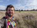
Made it
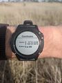
GPS proof
GPS proof again
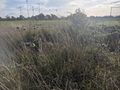
View from the hash
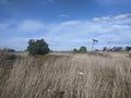
View back towards the train line


I went back round the end of the fence again, retrieved my bike and continued on my way. I hadn't decided how I was going to get back yet, maybe back the way I came, maybe just to get a train, but as I was right by the Laverton creek, and I saw there was a path starting right there taking me along the creek to the coast, I decided to take the coastal route, back along the edge of the bay past Altona and Williamstown. This was a good decision, I saw a very large variety of nice birds going home this way, including what I think might have been an eastern great egret. At least, it was a very large white bird, seemingly almost pelicanish in size, with a long yellowy/orangeish beak.
I also saw many swans. I eventually got home, having done a bit over 50km in total.

Achievements
John earned the Bicycle geohash achievement
|