2022-08-24 35 -83
| Wed 24 Aug 2022 in 35,-83: 35.0674853, -83.4622343 geohashing.info google osm bing/os kml crox |
Contents
[hide]Location
Almost at the top of Little Pinnacle peak in the Nantahala National Forest
Participants
Getting There
For J's birthday weekend (08-19 to 08-21), we got a massive 'cabin' between Gatlinburg and Pigeon Forge, TN. I've never been 'glamping' but I feel like this was it; 8 bedrooms on two floors, each having its own bathroom. Pool table and arcade on the second floor, and a hot tub out back on an enclosed porch. And there was a row of about 7 or 8 of these plopped into the middle of the wilderness about a KM or so from the main road.
It wasn't the celebration we were hoping for, but it was still a lot of fun. Unfortunately, two friends dropped out at the last minute due to Covid, but there were 6 of us for the first night and 5 for the remainder of the weekend. We drove halfway on the 18th and we picked up a couple that flew into Knoxville on the 19th on our way. It was too early to get to the cabin, so we found a Brewery in Knoxville for lunch before heading to settle in. I needed to pick up a friend of hers who was flying in to Knoxville around 18:00 so I dropped them off in Gatlinburg and headed back to Knoxville. The parking/crowds/walls of tourist trap attractions was atrocious and I ended up just booting them out at a red light so I could get out of there. I was horrified after being in nature for the past couple days. Another friend was driving in so she met them there and drove them back to the cabin so I didn't have to pick them up after. We did go back into Gatlinburg the next day to wander around and hit Anakeesta which was much more bearable as it was at the top of the hill away from everything else. That evening, we hit Pigeon Forge for some beers and dinner and I realized as horrifying as it is, Gatlinburg's setup is much better as you can park for the day and walk around the whole town, where Pigeon Forge was very spread out and you couldn't walk place to place. Still, give me the woods any day over a Tourist Trap 'town'.
Funny story, while at Anakeesta, we went to the very top of an Artwork Structure which had a 360 degree view of the mountains around us with a panoramic diagram naming the peaks at each of the 4 main compass points. On one of the diagrams (either North or West), I saw a peak named Holy Butt, which of course I pointed out to everyone. The next day, everyone wanted to go back into Gatlinburg to explore a bit more so I decided to break off and go for a hike instead. Looking around the area on AllTrails, I found a couple good options up in the mountains, and then I saw it...Holy Butt! With a trail that went not to the peak, but close! So that's where I hiked to. Turns out I couldn't get to the actual top because it was starting to get developed and there were a bunch of houses built along the road right there with a house right at the peak. Annoying, but at the trail entrance from the road is where I had lunch and turned around.
After the weekend, the plan was to take a week and drive back. We hiked in the Great Smoky Mountains and saw a (fortunately small) black bear that ran away when we started making noise. It was also way down the trail too so I'm not even sure it saw us. On our morning drive where we were heading to Asheville, we stopped at a diner on the side of the road for brunch while I looked up the hashes for the day. Nothing had been close or reachable so far on our trip and J was getting antsy. She knows how much I like playing this game and is always up for a random adventure. Turns out today's hash looked really reasonable and possibly even accessible...if the road going up by the hash was open that is. If there was a gate at the bottom and it was closed, we weren't going to walk the 5 miles/8 km up the mountain. Also, it was an hour in the wrong direction so I really had no intention of going, but J was all for it and we really didn't have much planned for Asheville, besides a bunch of breweries and dinner.
The Actual Expedition
So we were off, and we passed close by where we stayed the night before too, but no matter, we were Geohashing! It was mostly highways to get there, and it looked on the map like a research campus so J looked it up while I drove to find out more about it. It's relevant because the road up the mountain seemed to go right by the headquarters building and if they controlled the road/access, it might be the end of the line for us. Coweeta Hydrologic Laboratory studies the long term ecological impacts on water and the water basin of the Appalachians. While we drove by the offices, they didn't restrict the road going up the mountain (although there were study sites up there) and we were able to drive up. Still really close to the bottom of the one lane dirt road, we came across two horseback riders. I pulled off as best I could and just stopped while they went by so I wouldn't spook the horses. They initially seemed to wave me forward, but it was so tight anyway, it was safer for everyone to just wait.
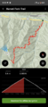
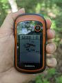
As we continued to drive up (in J's small car), she was worried it wouldn't make it up the steep road, but with all the switchbacks and the Laboratory (guessing here) somewhat maintaining the road, it really wasn't that bad. There was one section that was very steep, but getting by there, I knew we could make it all the way if we wanted. About half way up, I was starting to look for a place to park, but J said to just drive to the hash and we could walk around after. We didn't meet anyone else on the road, not shocking, but if we did, one of us would have had to find a pull off to swing into to let the other go by. We used one of these to park and we then had a couple hundred meter walk back down the road to the hash. It ended up being a ways off the road, and J didn't want to take the chance of twisting an ankle in the underbrush so she stayed at the road. Doing the GPS dance, I got a good reading and made my way back to her.
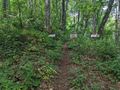
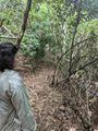
We then continued on our walk up the road and I'm glad the hash landed where it did. Any further and the road would have ended on us. There were barriers, but openings for people to walk by and the old road was still passable for a hiker. Going through a tunnel of bushes, J stopped and had a weird look on her face as I was taking a picture of her. Catching up, I knew we would have to turn around right here. She was already getting nervous of the remoteness and then she saw The Sign; 'Bear Sanctuary'. It would have been cool to hike to the top of the mountain (or wherever this road went before ending), but we headed back to the car. J felt bad for making us turn around because she just wasn't that comfortable, but she said she wanted to make it up to me so she suggested some Geoflashing back at the car. Nothing happened at the hash, so it really doesn't count, but we took our time before driving back down.
Geohashing-wise, there really wasn't much going on for the rest of the trip, but we got in plenty of Breweries, more hiking (Shenandoah), a cave tour and found some great places to eat on our way home.
Photos
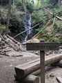
The start/end of my hike to Holy Butt. This area near the trailhead was packed with people on my way out but had the whole place to myself on the way back.
Hiked to Holy Butt!
I came out of the woods, but this was about as far as I could go. The driveway and land was posted.
Our hike in the Smoky Mtns where we saw the bear.
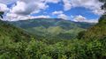
One of the many Smoky Mnt vistas.
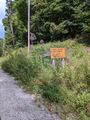
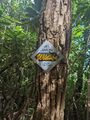
Taken on the way out, one of the signs at the bottom of the road.
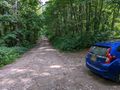
We managed to make it up and parked.
Made it!
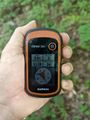
Accuracy.
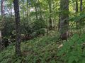
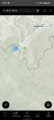
View North at the hash.
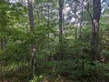
View West.
View South.
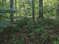
View East and back toward the road.

Standard Stupid Grin and a new Graticule!
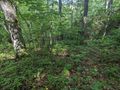
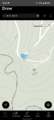
View of the hash.
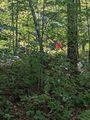
There's J at the road waiting for me.
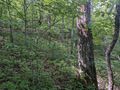
The road ended just past the car around the next bend...
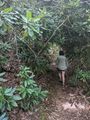
but we kept going anyway.
J looks defeated, but I'm not sure why...
Clearing the bushes we just walked through, I can see why she's upset. Side Note, the scratches on the side are from Porcupines who, for some reason, like to nibble on signs.
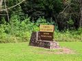
Back on the road, we passed this National Forest sign indicating the Laboratories.

Burial Beer Co. in Asheville, NC has a great setup, but mostly focuses on IPAs and I wasn't a fan.

I think GreenMan was my favorite Asheville Brewing Company.
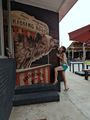
Stopping at a BBQ place for dinner, J got friendly with a bear. Apparently, urban bears are ok.

The next day, we stopped at the Biltmore Estate. Super fancy, but well worth the stop.

After the house tour, we walked around the gardens and on the estate trails.
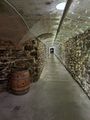
Before finishing up at the Wine Cellars for a tasting.
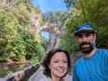
The Day after that, we stopped at Natural Bridge (VA) before heading to Shenandoah.
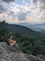
Absolutely stunning hike in Shenandoah, before our last stop in Winchester, VA.


Ribbons
This user earned the Land geohash achievement
|