2022-09-04 51 9
| Sun 4 Sep 2022 in 51,9: 51.3411326, 9.9008918 geohashing.info google osm bing/os kml crox |
Location
In a forest east of Unterrieden
Participants
Plans
Do a little walk to the hash sunday morning...
Expedition
Todays hash was very near the 2021-10-27_51_9 hash I did last year - the same climb [parking at 170 m above sea level], the same hill (called Witzgenstein) [with its peak at 336 m above sea level] - only a little bit more on the top today. And also a bit more off the road - which meant going some 150 meters off the main path, struggling through the forest with lots of vegetation and, for all, being pretty steep here and there... but, with a bit of luck, I managed to reach the top of the Witzgenstein and from there, it were just a mere 40 meters to the hash location.
I found the hash to be an old tree trunk in the middle of nowhere and didn't have to do that much of a hashdance to locate the exact coordinates within less then one meter! Took pics for evidence, enjoyed this peaceful moment for several minutes and, as in october 2021, got back onto the path and continued my walk to do a nice hike through this delightful forest. Really, I'm enjoying this area so much - no one seems to get out here, untouched nature, pretty exciting if you ask me!
Photos
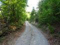
On my way to the hash
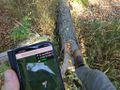
The hash was this tree trunk
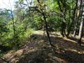
Hash surroundings

The hasher at the hash location
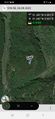
Proof


