2022-10-13 42 -78
| Thu 13 Oct 2022 in 42,-78: 42.5829298, -78.0566932 geohashing.info google osm bing/os kml crox |
Location
Letchworth State Park, on the Mary Jemison Trail
Participants
- Pedalpusher
- Simon the dog
Expedition
I saw this was reachable and right off a trail when the hashpoints were posted and I thought I had enough time to get there and hike to it before the sun went down. After work, I got Simon ready and took care of Myka since she was not going to come with us. I left a little later than I wanted to, but was able to get to Letchworth around 17:45 or so and parked by the iconic Railroad bridge at the Southern end of the park. We then followed the walking trail along the Gorge to where it cut into the woods across the main road. It was a steep little incline, but once we crested the hill, it flattened out almost completely.
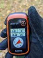
Following my GPS, I was surprised to learn the hash was right on the left edge of the trail. From the Satellite pictures, I misremembered and thought it was on the right side. Good thing it wasn't too much further to the left as we hit another small incline, we were walking along a steep but narrow ravine and then we passed a dam across the whole thing which created a narrow but very long pond that was pretty scummy. The edges down were pretty steep too so I'm not sure if I would have been able to get there otherwise. Instead, with a little GPS dance along the very top of the ridgeline, I got a perfect reading and a couple more pictures of the surrounding area.
I was then planning on walking the rest of the way around this loop, and then heading North, across the Railroad and into the woods on the other side for a Hash Collision (HM) and then continue on that trail back to the main road and walk back along the Gorge. The short tunnel under the train tracks was neat, but getting to the other side, I decided to skip the cache. Sure, I was running out of daylight, but my bigger concern is that Letchworth is LOADED with ticks and I just didn't want to deal with them. So we enjoyed our hike instead. At the end of the trail, I found the Seneca Council House and historical area which I explored a bit but I didn't take any pictures because dusk was settling in. You can check out this site though for info on it which I found interesting.
Walking back along the gorge, I admired the colors of the trees as they are just about at Peak Fall Colors over the Middle and Upper Falls. Getting back to the car, I fed Simon his dinner before we headed for home. I had to be careful because the deer were out and I almost hit a small one that ran out into the road in front of me. Fortunately, I saw it coming and was able to slow down enough for it to get across. I then closed out the night by watching the Buffalo Sabres (our local National Hockey League Team) come back and crush the hated Ottawa Senators at a local bar.
Possible Last Man Standing, but I'll wait a while before claiming the ribbon. Another expedition was posted a month later and this no longer qualifies (See below).
Photos
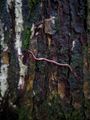
It's just an earthworm, but why am I showing this to you?
Because I found it over a meter up a tree trunk. Not sure where it's going, but it's tenacious!
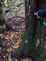
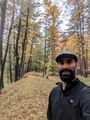
Made it to the Hash!
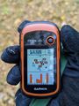
Accuracy.
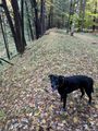
Simon, patiently waiting for me to get my pictures at the hash.
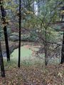
View West and across the ravine/pond.
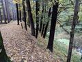
View South and from where we walked in.
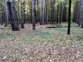
View East.
Apparently, I didn't take a view North, but that's the direction over my shoulder.
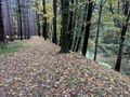
View of the hash, next to that larger tree on the edge of the dropoff.
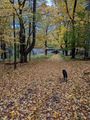
Continuing down the trail, we are about to go under the railroad tracks.
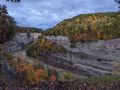
Back at the Genesee River, a view below the Middle Falls.
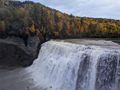
The Middle Falls.
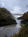
The Iconic Upper Falls, under the Train Bridge.


Ribbons
This user earned the Land geohash achievement
|
Expeditions and Plans
| 2022-10-13 | ||
|---|---|---|
| Buffalo, New York | Pedalpusher, Simon the dog | Letchworth State Park, on the Mary Jemison Trail |
| Mannheim, Germany | GeorgDerReisende | The hash lay on an abandoned industrial site in Gernsheim. |