2023-01-29 42 -78
| Sun 29 Jan 2023 in 42,-78: 42.1322382, -78.7369333 geohashing.info google osm bing/os kml crox |
Contents
[hide]Location
Allegany State Park, in the woods past the Stone Tower
Participants
- Pedalpusher
- Simon the dog
Expedition
Writing this up a couple months later so some of the details may have been forgotten.
Being a Sunday, I didn't have any time restrictions (like an Official Meetup) but I usually like to get to the Allegany hashes early in the afternoon so I have time to hike around. In this case, I must have left after lunchtime with Simon. This isn't Myka's favorite time of year and while we didn't have any snow around, it was still pretty chilly and she would rather curl up on the couch any day.
This winter was pretty crazy. We had two massive snow storms, one a blizzard over X-mas weekend, but after both, all the snow was gone within a week or two, and practically no snow otherwise. So getting to Allegany, I was surprised there was still a lot of snow on the ground. Not enough for the snow shoes, but enough to get in the boots on occasion if the gators weren't adjusted correctly. ASP is at a higher elevation than Buffalo so that's enough at times to allow the snow to stick around longer up there. I didn't mark this as a Frozen Hash so I'm thinking the temps were high 30's or low 40's (~4 C). I parked at the Summit Cabin area as there's the main Ski Area trailhead across the road and a large parking lot there with a dirt road that goes by the Stone Tower. There's also a trail that goes in the woods and mostly along the road, but with the road closed, we just stuck to the road where it was easier to walk.
Past the Stone Tower, there's a radio tower up another driveway off the stone tower road where it curves back to the main road through the park. We kept going up to the radio tower and around it where we found some sort-of trails which then connected to some logging roads that were recently created to log the forest on the ridge we were walking along to the hash. We were able to get much closer than I thought as I figured to be bushwhacking through the forest from the radio tower itself. Where the logging roads ended, we had to navigate some really thick brush and left over treetops, but beyond that, the forest was pretty open.
Continuing toward the hash, we finally had to descend from the ridge to get to the hash, but before getting to the hash itself, we came across some trail markers indicating there was a mountain bike trail here. This trail is not on any of the ASP maps I'm aware of so I'll definitely have to come back and explore this area more and find where this trail starts/ends.
I was able to use that trail for a short distance but once it turned away from the hash, I broke away from it. There was a bit of a GPS dance around the hash area, but I was able to get a good reading and some pictures of the area.
On the way back, we needed to get back to the top of the ridge which was pretty steep but I just took my time and did a little zig-zagging up the incline. I considered following the bike trail that was sort of going in that direction, but I didn't want to take the chance if it didn't go back up to the tower. Being called the 'Stone Tower Single Track', I probably could have done so, but really didn't think about it too hard at the time and was just focused on retracing my steps.
Back at the logging area, it was again a tough time getting through the boundary area, but back on the logging roads, I had a much easier time. Getting back to the Stone Tower, we stopped and explored the unique landmark like always and took a few more pictures before getting back to the car.
Photos
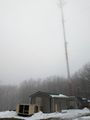
Walking past the radio tower in the foggy atmosphere. I think the warmer day with the snow still on the ground caused the fog.
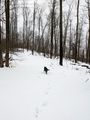
Past the radio tower, we found these logging roads that were still going the right way.
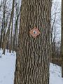
Almost to the hash, I found a new(?) trail.
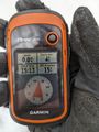
Made it!
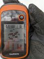
Accuracy.
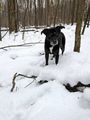
Simon at the hash.
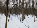
Writing this up late, I don't know what direction is what. From the hash, I think this is North.
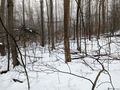
Pretty sure this is East back toward the Stone Tower.
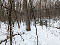
That would make this South...
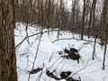
...and this West.

Stupid Grins at the hash.
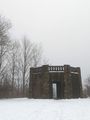
Getting back, we stopped at the Stone Tower.

More Stupid Grins.
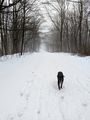
On the way back along the Stone Tower road, Simon ran back and waited for me while I took a couple more pictures.


Ribbons
This user earned the Land geohash achievement
|