2023-02-08 65 26
| Wed 8 Feb 2023 in 65,26: 65.0801139, 26.2065698 geohashing.info google osm bing/os kml crox |
Location
On a gravel road in Niemiharju, Ylikiiminki, Oulu.
The point on a topographic map: [1]
Participants
Plans
The first potentially doable geohash near my new home location, and in a virgin graticule! Some other ones have been accessible too, but I have been too occupied with something more important.
I should be able to take a bus from Oulu to Ylikiiminki and bring my bicycle in the bus. I would then only have to cycle about 15 km from Ylikiiminki to the hashpoint and back and a few kilometres in Oulu. The other option is cycling the whole distance of about 85 km, which is not going to happen after a full workday in the winter. Let's see if I can leave from work early enough to make this work.
It is possible that the bus driver will refuse to let me travel with the bicycle if the bus is full. If this happens, I will just abandon the expedition, but it hopefully will not.
Expedition
I was able to arrange my work so that I could leave at 14:50. I cycled to the bus station where bus 36 to Ylikiiminki departed at 15:10. I did not know where exactly it would depart, so I did a few loops looking for a sign or something. Finally I asked a bus driver having who was having a break, and he told me it would leave from a station platform. All right. I guess I would have figured it out if I had just waited and watched. I had plenty of time to spare, so I was not in a hurry.
I got on the bus and out at Joloksentie stop at 16:07. I then had 68 minutes to cycle about 15 kilometres and to document the visit until the returning bus departed at 17:15. The next bus would leave two hours later, so I really needed to make it back on time. I was confident that I could do it though. The timeframe was convenient because I would get to enjoy the final moments of daylight. An hour later I would have had to cycle all the way in the dark.
The roads were in pretty bad condition. The first larger road was covered in very rough and uneven ice and a thin layer of powder snow which obscured the hard surface. I had a few scares but kept my balance all the way, thanks to the studded tyres. The second smaller road was covered in hard snow with an extremely rough surface which caused strong vibrations to the bicycle and me. It caused my headlamp to detach and drop down and a connection of the front mudguard to break off. Thankfully nothing actually broke, and I was able to fix everything.
I reached the hashpoint which was on the side of the road at 16:31, and I did not need to walk in the deep snow at all. I got the GPS receiver out of the pocket, turned the brightness up for proof photos, and it promptly shut off. Damn! The batteries should not have been close to dying yet, but apparently the cold was too much for them. I tried to turn it back on, but it turned off right away. I did have the tracklog as a backup, but I still wanted to get pictures of the screen, so I removed the battery cover and tucked the device under my shirt to warm it up with my body heat. It worked. I kept the screen at the dimmest level and took the photos which turned out surprisingly well, perhaps thanks to the quickly diminishing daylight. The sun had already set a few minutes before, at 16:20. I took a few more quick photos and began to cycle back.
After cycling a little bit, I remembered that I had brought a thermometer to measure the temperature. Being in a bit of a hurry, I had forgotten it at the hashpoint. About a kilometre from the hashpoint and in similar terrain it showed −1 °C which is exactly what was forecasted. I could tell that the snow near the hashpoint was loose instead of sticky, indicating that it was freezing, so I think I can claim the Frozen Geohash achievement. Strong headwind on the way back felt even colder than that and slowed me down, but I just had to keep pedalling. I was getting tired and cold but did not want to risk missing the bus. Finally when I checked the time entering the village, I realised that I would be well on time and could take the last half a kilometre easy.
I got to the bus stop of Ylikiiminki where the bus was already waiting at 17:09. I hopped in and got off in Oulu at Rautasaari and cycled a few more kilometres home. I was beginning to feel seriously cold especially in my feet, so I immediately heated the sauna up and took a long bath when it was warm. Very nice!
I had some trouble with inconsistent distance readings from the GPS receiver, but after looking at it I believe that I cycled about 22 km in total and travelled about 78 km by bus. I had to pay 19.20 EUR for the bus journeys including 4.00 EUR in extra fees for bringing the bicycle.
Tracklog
Photos
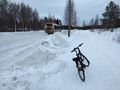
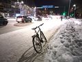
After getting off the first bus.
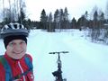
Selfie at the hashpoint.
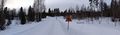
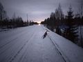
Surroundings of the hashpoint. The bicycle is parked at the coordinates.
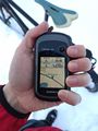
Proof of location.
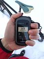
Proof of date and time.
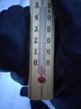
Proof of temperature.
Entering Ylikiiminki and crossing the Kiiminkijoki river.
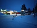
The bus stop in the village centre, the bus is already waiting.
Back in Oulu.


Achievements
Kripakko earned the Graticule Unlocked Achievement
|
Kripakko earned the Land geohash achievement
|
Kripakko earned the Public transport geohash achievement
|
Kripakko earned the Frozen Geohash Achievement
|