2023-03-07 58 5
| Tue 7 Mar 2023 in 58,5: 58.6335445, 5.9437915 geohashing.info google osm bing/os kml crox |

Location
About 200 meters from the road up to the top at Urdalsnipa, Bjerkreim, Norway.
Participants
Plans
Expedition
Today's walk was quite long, I walked a total of 8.98 km. First I drove about 31 km and found a parking space, this was 253 meters above sea level and I walked a road up to about 470 meters above sea level where I walked about 200 meters from the road to the hash point. It was rough terrain so it was difficult and it took some time to get close to zero.
After the hash was registered, I went back to the road and continued up to the top of Urdalsnipa. At the top there is a giant communication tower which I think has something to do with telephone, radio, television and possibly other communication. The peak is at 561 meters above sea level.
Average heart rate on the trip up the mountain and down again was 143 bpm, maximum heart rate 184 bpm.
Tracklog
Photos

Urdalsnipa @58.6336,5.9438
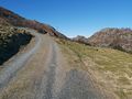
The road up towards the hash.
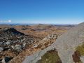
View to the northwest.
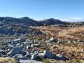
View to the southwest.
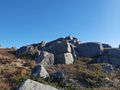
View to the east.


Achievements
Pica42 earned the Land geohash achievement
|