2023-03-22 52 6
| Wed 22 Mar 2023 in 52,6: 52.1715436, 6.0893828 geohashing.info google osm bing/os kml crox |
Location
An artificial woodland bog (veenbos) between Apeldoorn and Zutphen.
Participants
Plans
This will be my first geohash. It looks to be an easy bike ride, followed by a short bit on foot, and then about 40 meters through woodland. The weather predicts light rain, but nothing too bad. I considered going for tron, but I don’t think I can carry my bike through 100 meters of woods.
Expedition
I had already biked 70% of the route towards the geohash just on regular bike rides, so I didn't have much trouble there. I was dressed a bit too warmly for the weather, but it was manageable. I parked my bike at the start of a short forest path that would bring me within 40 meters of my location. When I came close to the geohash site, it turned out to be a section of the forest that was artificial wooded bog. These areas are inspired by the pre-agricultural state of the region, which had trees forming patches of dry earth surrounded by still water forming bogs or creeks. I walked around the section of forest where the geohash was, and picked a route I hoped would get me there.
Just 25 meters from the hash point, a creek blocked my path. It felt just around the limit of what I could jump across, so to play it safe I went for a log that lay across the creek. Unfortunately, this log was surrounded by brambles, sharp enough to pierce my jeans with ease. I seriously considered going back, but I didn't want my first geohash attempt to end in failure, so I carefully moved through the bramble patch, only getting pricked a couple hundred times, and managed to cross the log.
The other side of the creek brought some more brambles. The creek wasn't just a single ditch; the section that now surrounded me was E-shaped, and the log put me on the bottom right of the 'E', with brambles blocking my way further right towards the hash. Luckily, the middle bar of the E was narrower than the left side, so I managed to jump it, and then jump another creek. From there, I only had to crawl under the branches of a conifer, after which I entered a stretch of much drier land.
A couple of thorn pricks richer, I had made it to the hash point, though strangely nobody else had decided to attempt this one...
On the way back, not wanting to brave the brambles again, I decided to risk the jump over the wider creek. I tossed my bag across, then carefully jumped, luckily only getting off with a bit of splash on the outside of my jeans. From there it was just a matter of going back to my bike and cycling home.
Tracklog
Photos
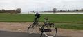
My trusty steed.
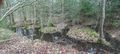
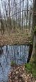
The E-shaped creek that I had to cross.
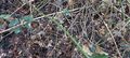
A thorny situation.
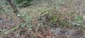
A log covered by brambles.

Got there!
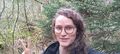
Selfie.
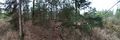
Panorama of the geohash site.
Jump back to safety.


Achievements
This user earned the Bicycle geohash achievement
|
This user earned the Land geohash achievement
|