2023-07-02 50 8
| Sun 2 Jul 2023 in Frankfurt am Main: 50.2552030, 8.5522493 geohashing.info google osm bing/os kml crox |
Location
In the forest on the side of the Herzberg above Bad Homburg.
Participants
Plans
The hash point was in the forest on a nearby mountain, with a pretty hefty climb it would be a great mountainbike tour.
Expedition
To the hash point
I took my mountainbike and rode west and up on familiar paths. Once i got onto the Oberer Rotlaufweg it was a straight (if steep) climb to the Saalburg. Even past the Saalburg the climb continued until reaching the highest point of the route close to the Ernesberg. In total i climbed about 320 meters in 8.5 km which gives a 3.76% average inclination. From there it was only a short downhill rush to get to the closest point to the Hashpoint on the paths. I choose to approach the Hashpoint from above, leaving my mountainbike on the path about 60m from the Hashpoint. Through some pretty wild but beautiful forest i made my way to the Hashpoint.
At the hash point
The hash point was in a naturally wild mixed forest on the mountainside of the Herzberg above Bad Homburg. For some reason the hashpont again decided to fall within a spot of dense trees but i still managed to get within 1 meter of the Hashpoint.
After taking the prerequisite pictures i made my way back up to the path as there really was no good place to sit down at the hashpoint. The ground was very soft from the natural forest underbrush, old twigs and lots of leaves and in places still damp. All the tree trunks and stumps were either old and rotten or jagged from their natural collapse.
Back at my bike on the path i had some snacks in the form of a sugar-waffle, some cookies and blackcurrant lemonade. The forest was very peaceful. Away from all roads it was perfectly quiet apart from the sounds of the forest.
Back home
As the way to the Hashpoint was pretty much a constant steep climb i already knew the way back would be a downhill blast and it sure was. First i got back down to the Saalburg and decided there to take a different higher path back, instead of the Oberer Rotlaufweg i came on. I made one last climb to the Fröhlichemannskopf and rode one of my favorite downhill paths back home: The Thomasweg. Racing back home with an average speed of 37 km/h and top speeds above 50 km/h on gravel forest paths is always a blast.
The total tour length was 19.2 km
Photos
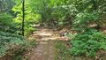
Path above the Hashpoint
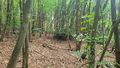
Hashpoint is in the center of the picture

Stupid Grin™ at Hashpoint
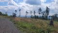
View on the way back
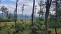
View of destination home


Tracklog