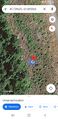
2023-07-09 45 -121
| Sun 9 Jul 2023 in 45,-121: 45.7396245, -121.8928632 geohashing.info google osm bing/os kml crox |
Location
In the forest north of Stevenson, Washington.
Participants
- Hamblingreen and his parents. This one was actually their idea. I'm starting to think they might actually go geohashing on their own when I'm off at school this fall.
Plans
Hamblingreen
My dad proposed that we go see the Tunnel 5 fire in Washington, which I thought was kind of a weird idea. Turns out he was tricking my mom and I into going geohashing! I figured him out before we left. We'll head up highway 14 in Washington and turn off onto some logging roads between Stevenson and Carson. The hashpoint is just before the tree line off of a gravel road in the woods.
Expedition
Hamblingreen
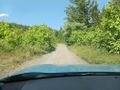
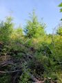
Beautiful! Driving along the gorge was such a treat and armed with sandwiches and watermelon we had a fabulous time. We arrived at the logging road uneventfully, but about half a mile up the gravel logging road my mom's fear of driving on steep roads kicked in and we pulled over and walked the other half mile to the hashpoint. We walked into some deforested area by about 50 feet, just before the tree line. 10 more feet off the road and we would've been forced to walk off a cliff!
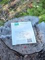
After stepping over sharp sticks and through some brush, we found a stump that marked the exact location of the hash. Just behind the stump was a steep decline that led to a stream. We were fortunate that the hash didn't fall off that hillside or into the replanted areas surrounding it. It was just perfect! One poster and one Stupid Grin (TM) later and we were on our way.
We didn't end up going to see the fire since it was farther east then we expected, but the vistas in the gorge were beautiful as always! No major distractions or detours this expedition, just pretty views and an uneventful drive back. This was however my 2^3rd attempted expedition and my first in the 45, -121 graticule.
Wait, what's that I see? Michael5000 visited the geohash too? No way!! That's crazy. And I tried to edit the wiki at the same time as him. What a day! On my 8th expedition, evidence of another geohasher. I'm astounded
Michael5000
So I took a long drive, and went for a run in Madras, Oregon, and then drove up to The Dalles and had lunch. Then, since there's a stretch of Washington 14 that's closed due to a recent fire, I crossed the Columbia on the Bridge of the Gods at Cascade Locks, and then backtracked east a few miles to Stevenson.
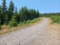
From Stevenson, I drove north to Skaar Road, then felt good about my new vehicle as the road degraded to a rough one-lane gravel track. About a kilometer from the hashpoint, I found a good place to park, and then got out my bicycle to make it the rest of the way to the hashpoint, because that's how I roll.
But, that didn't work. The road kept gaining elevation, not quite as steep as a staircase, but -- wow! -- close. After a while, I just abandoned my bike and just kept trudging upwards.
The hashpoint was down a steep decline from the road. As I approached it, and tried to figure out the best way to make my way down to it, I noticed something unusual: there was something there. Which was weird, because when you try to explain geohashing to a civilian, then always ask "what will you find at the hashpoint? And the answer, of course, is "Nothing. Duh." But there was a thing at this hashpoint!
A geohasher had been here before me! And, wow -- I think it's been more than 10 years since I've found evidence of a previous geohasher at a hashpoint. I suspect Thomcat. Or maybe Hamblingreen. Or perhaps Fippe on Summer holiday, keeping me humble. Or Frogman, stealthily, but he was in Toronto just yesterday, so that seems unlikely.
So that was awesome!
Tracklog
Photos
Skarr Road gets rugged

Trudging uphill
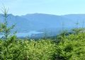
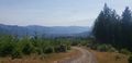
View back towards Cascade Locks and Bridge of the Gods
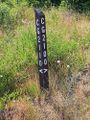
CG Roads must be Columbia Gorge roads
The hashpoint is over on the left
OMG! OMG!

OMG!
Looking back towards the road from the hashpoint
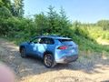
Always good to get back to the expedition vehicle

Stupid Grin (TM) with Crox poster
Right on!!

Made it to the hashpoint
Beautiful vista in the gorge


