2023-07-19 47 -122

| Wed 19 Jul 2023 in 47,-122: 47.2986629, -122.6125718 geohashing.info google osm bing/os kml crox |
Location
In the estuary at the north end of Wollochet Bay, Gig Harbor, about a mile from Gaelan's house.
There's a peninsula that appears on Bing Satellite, but not OpenStreetMap. If it exists, the hashpoint'll be much closer to land (and therefore easier to reach).
Participants
Plans
Walk over ASAP after I saw the hash (3pm-ish), see if it's accessible on foot. Either way, return around 8pm when the tide's up for a water geohash.
Expedition
Uneventful walk down to the Wollochet Bay Estuary Park. I can see through gaps in trees that the area in question's almost all mudflats and not water at the moment - a good sign. Down a very overgrown path from the grassy field forming the "park" proper to the tideflats, then a rather nasty walk across the tideflats to the hashpoint. Turns out it's very difficult to determine where'll be mostly sturdy and where your feet will sink way down. Thank god for good waterproof boots.
Turns out the peninsula in question does exist (should fix OSM when I've got a moment) - so I got to the peninsula, clambered up onto it, across to right near the hashpoint, back down onto the mudflats for the hashpiont (which, thank god, was on fairly sturdy mud), get the photos. Then back up onto the peninsula to get up to East Bay Drive, which it turns out provides much better access to the hashpoint than the park I entered from - though there was some surprisingly nasty bushwhacking between the estuary and the road! From there, I walked back a bit before getting picked up by car, as we were heading out anyways.
Got dark before I had time to go back out by boat, so no water geohash for me. But I did it! After various failures, first successful hash!
Tracklog
Photos
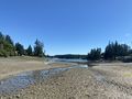
View from the hashpoint
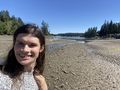
Grin(TM) at the hashpoint
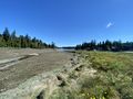
Right: the peninsula that, according to OSM, doesn't exist


Achievements
Gaelan earned the Walk geohash Achievement
|