2023-07-23 42 -79
| Sun 23 Jul 2023 in 42,-79: 42.4748881, -79.3658642 geohashing.info google osm bing/os kml crox |
Contents
[hide]Location
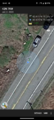
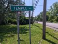
Edge of Rt. 5 and next to Canadaway Creek, just South of Dunkirk
Participants
Expedition
With Yesterday's successful expedition, I thought I could turn this into a Consecutive Geohash and also a Hash Collision event as there was a GeoCache on the other side of the creek. From the satellite pictures, it looked like this was a popular fishing area and cars park right at the GeoHash for access to the creek/lake.
After cleaning up a bit from our X-mas in July party the day before, we had some lunch and then J joined me on an adventure. I figured we could stop somewhere down that way for a hike in order to make the drive worth it as well. It was pretty much highway driving and took about an hour, but we found our way without any trouble and stopped at the Geohash first. There were cars parked so we went to the end of the line, and just past the hash to park. J didn't want to walk over to the hash so she stayed in the car(but I think she still counts as it was at the edge of the driving lane and passed right next to it sitting in the passenger seat).
I made a quick GPS dance to get a really good reading and a couple pictures. Back at the car, we backtracked across the creek and pulled over to find that GeoCache. I figured it would be an honorable mention, but after locating it, I was able to see the speed limit sign through the bushes that I stood next to at the Hash. I'll take credit for this as a full Hash Collision event! It's extra fitting that the name of the GeoCache is 'A Matter of Chance and Fortune'. After signing the unique log and documenting the collision, we headed for Boutwell Hill State Forest to explore another area I've never visited before. This forest has a bunch of trails through it and it turned into a very nice hike.
When we first arrived, there were 4 or 5 horse trailers in the parking area, but the trail we were on did not allow horses. I set my alarm for about 30 minutes and we had just crossed a small ravine on the trail when it went off. We were still feeling good and wanted to go a bit further so I set another alarm for 15 minutes. I'm glad I did because I had seen on the map that this trail went past a couple ponds, and with that extra time, we were able to see them. I don't know why, but I really enjoy seeing water on my hikes whether they are streams, ponds or lakes (but not rain, that just sucks).
On the way back, we were treated to a very unique sight. I saw two people coming toward us on the trail and as we got closer, I could see small forms on the ground moving, but they looked really weird to be small dogs. Turns out they each had Remote Controlled trucks and they were going for a 'drive'. The older guy asked us if the trail we were on was a loop and I said this crosses a couple trails ahead so you could probably turn it into a loop, but this trail goes the length of the State Forest and was about 7 miles (11 km) long. The younger guy looked to be about my age or maybe a bit younger and the older guy could have been his father, but we didn't chat too long. Back on our way, J and I had a laugh because we had never seen that before, but hey, if it makes them happy, who am I to judge? I go to random places to find an invisible random marker, so whatever. Haha.
Note: the next day's Geohashes turned out to be too far away or inaccessible so the Consecutive Hashing again ends at a two count.
Photos
Made it!
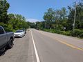
View North-ish and from where we drove in (also toward the cache).
View East-ish.
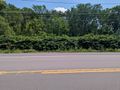
View South-ish toward where we parked.
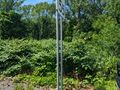
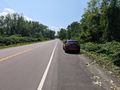
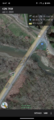
Importantly, the view West-ish showing the hash is right next to the Speed Limit sign.

Standard Stupid Grin.
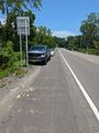
At least one guy would win the Curse of Unawareness this day. A look back at the hash area before driving over to the cache.
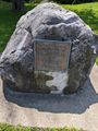
Cache landmark indicating this is the location of the first hostilities of the War of 1812. The cache page has a fantastic writeup on this.
Not taking a picture of the Cache itself, but a view from the Cache area back to where you can see the hash area for a Hash Collision event (you'll need to zoom in)!
Additional proof for Cache to Hash distance.


Ribbons
This user earned the Land geohash achievement
|
Pedalpusher and J earned the Hash collision achievement
|
Pedalpusher and J earned the Consecutive geohash achievement
|