2023-08-09 49 10
| Wed 9 Aug 2023 in 49,10: 49.3783590, 10.8166189 geohashing.info google osm bing/os kml crox |
Location
In the woods close to Wendsdorf, Großhabersdorf
Participants
Plans
On my way home from work in Erlangen, I'll take a detour to the train stop in Raitersaich. I'm planning to walk the path from Raitersaich to Wendsdorf and take a small 50 meters into the woods to reach the hash. Afterwards, I'll continue on to Großhabersdorf - and take a bus home.
Even though this is my first hash, I might try to do it as a Tron hash - I prefer my hikes that way anyways. However, this means I technically start (and end) my trip at Zirndorf rail station, and have to avoid crossing my tracks on my daily trip to work - and hope that the public transport heavy route I'm going to use doesn't cross itself in some obscure way.
Expedition
What initially was just a detour from my way home from work became much more of a challenge when I decided to try it without crossing my path. To make it be an (almost) full circle, instead of just the linear path between Raitersaich and Großhabersdorf, I have to include my usual trip to work (and back home) too. In order to avoid crossing my track, my way up to Erlangen will avoid Nuremberg and use the westerly train service, while my way down south will use busses well east of the tains, change in Nuremberg to the train towards Raitersaich.
But there are some interesting challenges involved when trying to navigate public transport without ever crossing your track. And they are - as it always is - hidden in the details.
Most train stations - as my home station in Zirndorf - only have one central tunnel to access the platform. If your train is particularly short and stops well short of that entry, you might be forced to walk towards the end of the train to get access to a door to enter it - and walking towards the end of the train is always a walk you will backtrack once onboard the train. I'm lucky today as my first train is a longer version and allows me to enter from my spot at the platform. I'm still nervous about maybe already having crossed my path, because the train station in Zirndorf has only one set of stairs to get to the platform - and it is oriented westwards, while my train leaves eastwards. I'll have to wait what the GPS has to say about it.
Even before I get to change trains, I encounter the next possible obstacle: The Siebenbogenbrücke, a 190 meters long railway bridge over a river and some wetlands. My train has to cross it eastwards to get into Fürth central station, and my connecting train will have to cross it again - westwards - to continue on towards Erlangen. In both directions I'll be driving on the rightmost of the 7 parallel tracks - approximately 20 meters apart, but only the tracklog will show if they are sufficiently far apart for my quality of GPS detection today.
In Erlangen I change onto my local bus service to get to my office. I noticed that my bus ride would take me very close to my path I'm going to take towards Raitersaich in the evening, so I leave the bus a few stops early and walk the remaining stations on a different road. I reach my office, carefully entering through one set of doors (and leaving the other set of doors for me to exit), and start working.
After work, I take a different bus to the airport. On my way to the bus stop, I almost meet the bus I used in the morning and left early, less than 10 meters away from my path. It was a good decision to walk the final stops in the morning
While the bus slowly drives towards the airport, I recognize another problem on the horizon: Theoretically, I drive towards the airport from a western direction, and my subway towards the central station will leave eastbound and then turn south. No issues here. But in practice, my bus takes a curvy route towards the airport on small roads. It is possible that the bus route does in fact cross the subway. I might have to do some extensive checking on this, because I assume GPS will not be great while in underground.
Nuremberg central station is special: Instead of one tunnel to access all platforms, Nuremberg has three: A eastern, middle and western tunnel. My train is going to leave westwards, so I use the eastern tunnel. This increases the chance that I'll be able to enter a train without backtracking. And as planned, when I exit the eastern tunnel, I enter the train towards Raitersaich at its end, and enjoy the ride.
In Raitersaich I exit the train and take a look. Raitersaich train stops's exit is well ahead of me, so I'm all clear. The hash is on the right hand side of the tracks. While there is a nice path visible from the train stop, there is also an (abandoned?) piece of track between the platform and that path. I'm not going to cross a track without permission, so leaving the station to the left and crossing at the next tunnel it is.
Sadly, this means another close call on crossing my tracks. I leave the station on a slope towards the tunnel, and the slope makes a tight U-turn to allow for a longer path and less inclination. A great idea in every plausible situation - except of course, in mine.
I already start to miss my hiking maps that I foolishly left at home today (I forgot). Map-Apps are decent when it comes to streets and navigation, but they really lack in their knowledge of tiny walkable paths, path markings and elevation changes. The path I want to take today to Wendsdorf doesn't even exist on my offline map.
There's some luck: When I enter the train stop, I see a fixed hiking map for the local area. It confirms my plans: The path I want to take exists, and it is reachable from the next track crossings - simple enough that I can hopefully remember it. But it also shows some things to worry about: As I already know, the hash is a bit to the right of the path in a wooded area. I know learn that the hash is also a bit lower (maybe 2-3 meters) than the path, so accessing it could be a bit difficult.
With this information, I follow my plan towards the hash. I enter the woods where the hash is in exactly as planned ("800 meters to the hash"). But a few meters in, the path splits. One part goes towards the left, the other towards the right. I need to go more or less steight ahead. I miss my hiking map. I don't want to try one path, see it too wandering far off and backtrack - that would make all my planning for not crossing my path moot. Why didn't I take a picture of that hiking map at the train station? That would have been smart.
Instead of making any decision, I follow something that goes straight ahead and almost looks like a path. It resembles a path close enough - although it is clear this hasn't been used for a bit by now, and I even get to join onto a bigger path again ("200 meters to the hash").
70 meters to the hash the path makes a turn to the right, while the hash is ahead ("70 meters to the hash"). I remember this from my plannings. At minimum that means I'm back on the path I planned on using. Good.
Even though straight ahead is clearly not a path, and has a lot of plant based obstacles - wild blackberries growing into thorny obstacles, young trees with all their branches and sticks at eye level, and stinging nettels high enough to almost touch my face - it also has a clear set of advantages: I will be able to approach the hash straight on, and I'm still kind of level with the hash. I will also have a clear path out from the hash - no turning around and trying to avoid my tracks, but simply turning to the right, up towards the elevation increase, until I'm back at my path.
I decide to go for it. There are clearly one of the slowest 70 meters I crossed in a long time, but I arrive at the hash and take a few pictures. Exiting is easy - back towards the path has way less plants and - at least upwards - the elevation change isn't really a problem. So I'm back to a regular path to Wendsdorf in no time.
In Wendsdorf I again miss my hiking maps. Wendsdorf has two roads, one westwards towards Weihersmüle, and one eastwards to Fernabrüst. I want to go northbound to Großhabersdorf - that's where my bus will pick me up, and there was supposed to be a non-road path there. But without a good map I don't know which of roads to take to get to that path up north, so I change plans instead: I'll now follow the roads up to Fernabrüst, and to Vincenzenbronn from them. These are plain old roads with sings on them, so I won't miss them, and Vincenzenbronn is just one stop east of Großhabersdorf on the same bus. I can just hop on there.
This plan works and I'm on my final leg to my starting point of Zirndorf. There's just a final issue: As we're past 6 pm local time now, the connection by bus from Großhabersdorf to Zirndorf will connect via backtracking again: My bus from Großhabersdorf is heading for Nuremberg, there's a bus from Nuremberg to Zirndorf, and you just follow line until they meet, and change directions. So I again leave the bus early and finish this expedition with a final 1 km walk home, instead of connecting to another bus.
On that final step, I find a nice restaurant and get a nice dinner. It's all worth it!
Tracklog
Photos

Proof
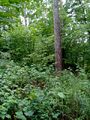
View from the Hashpoint
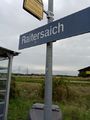
The train station of Raitersaich, the last train stop before the Hash
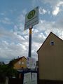
The first bus stop on the way back from the Hash
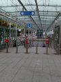
The subway station at the NUE airport - the one point on my trip where the public transport crosses itself


Achievements
Torodeas earned the Land geohash achievement
|
Torodeas earned the Public transport geohash achievement
|
Is it true that Torodeas earned the Tron archievement?
|