2023-08-25 48 11
| Fri 25 Aug 2023 in 48,11: 48.8696749, 11.0565193 geohashing.info google osm bing/os kml crox |
Location
In a forest next to Dollnstein
Participants
Plans
Torodeas (talk) wants to arrive at the Dollnstein train station at 17:51, and walk to the hash from there. This gives at ETA ~18:30 at the hash
Expedition
I'm starting to get used to these kinds of hashes by now: I pick a hash in some woods I can reach from some kind of public transport, I arrive at that train station or bus stop, and I have a nice hike in an unfamiliar location to the hash.
Today is one of these. Today's has is in the NW corner of the graticule, which is one of the easiest locations in 48,11 for me. There's even a nice train stop less than a km away from it, and that train stop has hourly service until later in the night - all good.
After arriving in Dollnstein, I notice the region is a bit hilly, and I'll have to leave the Altmühl's valley to get to the hash. Nothing crazy, but enough elevation to make me worry a bit about the tight schedule to be back for the 19:03 train home.
On the way to the hash I notice another issue: My app-based map just becomes blank. No more helpful streets, not even general features like 'woody' or 'urban' are displayed anymore. This makes it almost close to a No Batteries Geohash, and I did not prepare for that. My memory tends to be quite good, and so the general directions still available and my memory of 'there aren't that many streets in that approximate direction, just follow the street' worked out.
I even got the scheduled train 19:03 back, and didn't have to wait for another hour for the next one!
Tracklog
Photos

Proof
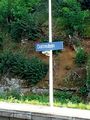
Dollnstein train station
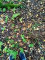
At the hash
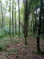
View from the hash

Almost a technical failure


Achievements
Torodeas earned the Land geohash achievement
|
Torodeas earned the Public transport geohash achievement
|