2023-09-23 50 8
| Sat 23 Sep 2023 in Frankfurt am Main: 50.4709988, 8.4559135 geohashing.info google osm bing/os kml crox |
Location
In the forest between Niederquembach and Kraftsolms
Participants
Plans/Background
Pretty much since I moved to my current hometown, I always wanted to ride one specific train line that starts here. It's a single-track non-electrified backcountry route through the Hochtaunus to nowhere, just serving a couple villages. Pretty much since starting geohashing I occasionally checked for hashpoints falling somewhere close to that rail line, so I would have a good reason to ride it other than just for the fun of it.
Now it had finally happened! And not only did it fall close to the rail line, it fell just a bit further than the very last stop, so I would get to ride the entirety of the rail line to get to the hashpoint. And on a sunny Saturday no less.
From the final rail line stop in Brandenoberdorf it would still be about 7 km of hilly terrain to get to the hashpoint, so I planned on riding the final bit by bike.
Expedition
To the hash point
I got onto the train with my bike in my hometown, and even tough the railline is not electrified, it is being fully served by newish hydrogen-powered trains. So even though, I am not (yet) a fan of hydrogen-powered vehicles (since that hydrogen is currently still being made from >90% fossil fuels), here I was glad to have the benefits of a modern electric train on a non-electrified rail line. As expected, it is a fantastic ride through the Hochtaununs countryside with lots of forests, fields and overall hilliness leading to some beautifully squiggly routing.
The villages along the way all seemed very quaint from what i could see from the train window. Maybe a future vacation destination, but that would also be somewhat weird only 30 min from home. Even with the quite hilly terrain, there are no major bridges or viaducts. But nearly at the end of the ride there is quite a decent tunnel of over 1,3 km.
Finally arriving in Brandenoberdorf after 52 min, I got on my bike to ride the final bit to the hashpoint. Only ~7 km, but with quite some inclines. Partially on main roads (but with little traffic), partially on smallish residential roads and for the very final bit on a forestry path.
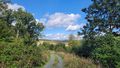
On the final approach i was worried, since a lot of the forest besides the path had thick underbrush which I would have had a very hard time getting through. But thankfully, just as the hashpoint was to be on my left side, the underbrush gave way to a clearing of sorts.
At the hash point
The hashpoint was only a few meters beside the forestry path in a lovely clearing, making access easy. I reached the hashpoint at 14:12, too early for the official meetup time, but due to the train schedules, 16:00 would have been impossible without wasting an hour.
After taking all the prerequisite pictures, I got out my lunch, wandered down the path a few meters to a good view and had a pretty much perfect picnic. I only stayed at the hashpoint for 15 min to eat lunch and relax a bit so I could get back in time to catch the train. It only runs once per hour at that very last stop (more frequently at stops down the line).
Way back
Unfortunately, my trusted biking app had failed me, so I relied on Google maps to find my route. Google maps suggested an alternative route to the way i came, going over a hill instead of through a neighborhood. Hoping for better views and a bit of cooling wind, I went over the hill.
That part went fine, the views and wind were as good as expected (there was even a family flying kites). But after riding down the hill on the other side, the path Google suggested simply did not exist. It went straight though a lovely green meadow with tall grass. Beautiful to look at, but not as great to have to ride my bike through to catch my train. Luckily, I found an actual path not long after and once back on the route i came in on, everything was fine. I arrived with plenty of spare time.
On my train ride back I had a seat with better views out of the window, so all the photos from the rail line below are from the way back.
Conclusion
Pretty much a perfect hashpoint expedition. Great weather, a long awaited train ride, some biking through nice villages and a little bit of lush forest, and finally, an easily accessible hashpoint with good views not far from it. 10/10, would hash again.
Photos
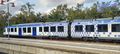
Hydrogen-powered train
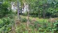
Clearing viewed from path
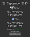
Proof

Stupid Grin™
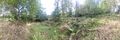
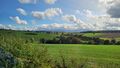
Panorama at the hashpoint
View a few steps down the path
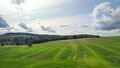
Train view
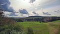
Train view
Train view


Tracklog