2024-01-28 56 -4
| Sun 28 Jan 2024 in 56,-4: 56.2739709, -4.5999016 geohashing.info google osm bing/os kml crox |
Contents
[hide]Location
Roughly 100m off of the Great Trossachs Path near to the shoreline of Loch Katrine.
Participants
Plans
KerrMcF
After volunteering, I plan to drive to The Pier Cafe on Stronachlachar Pier and then walk to the point via the Great Trossachs Path. I aim to reach the point at around 4pm but may stop at the cafe to get a drink for the walk. I should reach home at around 6pm, resulting in a total time of 4 hours for the expedition.
Expedition
KerrMcF
As planned, I set out from volunteering at 2pm for my hour-long drive to The Pier Cafe. The journey was fine, with some very narrow roads for quite long stretches, but nothing overly worrying. The weather was a different story. When I started my drive it was clear outside, sunny even. Gradually though, it started to rain. Not too badly, just a drizzle, then a shower, then a pour. Eventually, the conditions reached almost storm levels with torrential rain and fairly strong winds. Regardless of this, I continued on. If I reached the cafe and it was too dangerous to continue, at least I'd get to eat something.
I reached the Cafe with no issues and stepped out of the car to buy a ticket for displaying. It seemed like this was an optional process, but the signage said that the funds all went to maintenance. I hadn't expected this as the streetview had no indication of it, but in all fairness, it was 15 years old at this point. It wasn't any hassle to do this as the parking was relatively cheap, but immediately after stepping out of the car I was hit with a strong gust of wind. I should mention that as the cafe was on a pier it was surrounded on three sides by open water, which probably didn't help the wind situation, but it didn't put me off my expedition.
I went into the cafe but quickly decided after a minute or so that I would just return afterwards. I used the wifi from the cafe to load up the point (as there was no signal whatsoever) and began my journey. It was still raining at this point, but it was beginning to settle. In retrospect, I should have saved the point for offline reference, but I wasn't thinking about that at the time. I reached the Great Trossachs Path and began my walk.
So far, the atmosphere of the area was incredible. Despite the rain and wind, it felt extremely calming. In fact, the weather probably added to the experience. I took a photo for later reference and continued my journey. Shortly after, I encountered a very clear warning for the journey ahead. It was very likely to be intended for road traffic but regardless a warning of a road closure due to high winds only urged me on further.
I considered listening to music, but I'm glad I didn't. Once I was past the initial section of houses, the silence was astounding. The rain had eased greatly too, so I was able to take down my hood. Listening to the world around me was blissful as all I could hear were the waves gently crashing in the distance, the streams trickling past below me, and the wind blowing softly through the hills. I stopped and stood still quite a few times during my walk. It was nice, and my appreciation for the landscape I live near grew. But after taking a panorama (which upon viewing, could have been better) I kept following the path.
The next time I took a photo was on the approach to the hill area in which the point was located. I didn't know this before arriving, but if I wanted to reach the point I would have to climb hills off the path in clothing very much not designed for hill climbing. I kept following the path for now in hopes that there may be an easier access point to the general area, but couldn't find anything. I took another photo anyway to show what the climb looked like. Then I checked my phone again for the point. And it had vanished. Apparently, Google had determined that I was close enough and as such forgot my point. It couldn't find it again due to the lack of signal, and the only thing I was able to go off if I decided to continue was my rough memory of the location when viewing it beforehand.
I had no knowledge of the point, a lack of appropriate clothing and footwear for climbing on uneven grassy terrain, and a dissuaded mentality from the technological issues. But was I going to give up and start heading back? Initially, yes! That changed though, I realised that I'd come this far, and I'd gotten so close, and actually, the point was in an area that was relatively distinct on the satellite imagery. I'd turned away from a rural point before due to hills and I was not doing it again, so I went through the (unlocked) gate and started climbing.
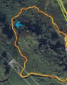
Immediately my feet were soaked. My previous dodging of puddles on the path here was meaningless now, but if I'd already gotten soaked I might as well continue. It took maybe 5-10 minutes to reach the area I thought the point might have been in and decided to walk around a bit, hoping to hit the radius. I wasn't going to stick around for long though, it was very difficult to navigate the hill and the less time spent on it the better. I had noticed on the satellite imagery that there was seemingly some sort of half-path leading from the nearby transmission tower back down the hill and decided to see if it was still there. It's fortunate that I decided to do this as I'll mention again later. I reached this path and continued down to find that the path led straight to the gate I had come through. Of course it did, why else would the gate have been there? I exited through the gate and began my journey back towards the car park, this time a little more wet than in the opposite direction.
I reached the cafe and walked inside, only to be greeted by some confused owners. They had stopped serving food and cleaned their drinks machines almost immediately before I walked in, 15 minutes before their closing time. This was fair enough, I hadn't expected to take this long and everyone else had left already, so I just bought a Mars bar and sat outside in the car. The wifi wasn't strong enough from the car to check if I had reached the point or not, so I drove back home first.
After the hour-long drive back home in the dark (which strangely made the narrow roads feel safer, probably because headlights told me of any oncoming cars), I checked my recorded route against the point. It took a bit of checking and double-checking, but I believe the comparison between the two highlights that I travelled directly through the point. It should be clear from the provided images. It wasn't actually during my wander in the area I thought the geohash location might have been, but was actually on the walk towards the path leading down from the transmission tower. As I said, very fortunate. Due to me not knowing where or when I would hit the geohash, I have no view from the point, unfortunately. Hopefully, the photo of the climb (which includes the general area of the hash) conveys the location well enough for all viewing.
With that proof, I can confirm that this was a successful expedition. My first non-retro in over 3 months (if we're excluding the air geohash, which we probably should, as I had no control over whether or not I reached that). It feels nice to be able to geohash again, and hopefully, as we leave the shorter days and harsher weather behind, it will become more regular again.
Photos
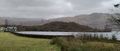
General atmosphere as mentioned
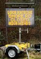
A good sign for the expedition to come
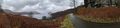
The could-be-better panorama
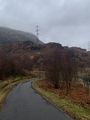
A daunting view for an unprepared geohasher
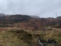
The geohash is up there somewhere!
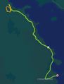
The route I took, green should be where red is
Highlighting the path through the point
The actual point itself on the same imagery

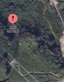
The details of this point including coordinates


Achievements
KerrMcF earned the Land geohash achievement
|
KerrMcF earned the One with Nature Geohash Achievement
|
Progress
| Council Area | Postcode | NUTS | Centicule |
|---|---|---|---|
| Stirling | FK(8) | UKM77 | 25 |
| Expedition Navigation | ||
|---|---|---|
| KerrMcF's expeditions | Next | |