2024-02-11 64 26
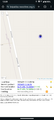
| Sun 11 Feb 2024 in 64,26: 64.5149618, 26.3456463 geohashing.info google osm bing/os kml crox |
Location
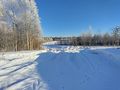
Next to a field near Muhosjärvi.
The point on a topographic map: [1]
Participants
- Kripakko
- Kripakko's fiancée
Expedition
It was an absolutely beautiful winter day: crisp, calm and sunny. We felt like going for a Sunday drive and spending some time outdoors. The plan was to visit this hashpoint first and then to go to a campfire place to light a fire and grill some sausages. The hashpoint was in an accessible location almost next to a road and a field, and would thus not be too difficult to visit. There would likely be a lot of snow in the forest, but it would not be a huge problem. I drove us to where the snowy field road intersects the main road and parked the car so that it was almost completely off the road but possible to get out.
I was testing the Quick & Dirty Geohash Navigator, my newest creation. I trusted that navigating to the hashpoint would work without issues, but I was not sure if the tracklog feature I recently created was stable. Based on previous testing, I thought it was, but disappointingly (though not very surprisingly), the web browser unloaded and lost the recorded tracklog after I took the third photo. It was not recoverable anymore. Anticipating this, I had brought the GPS receiver in my pocket and had it record the trip as a backup, which worked extremely well as always. Navigating to the hashpoint and documenting proof then went flawlessly.
There was indeed about 60 cm of snow in the forest. My boots were not that tall, but since it was pretty cold (−19 °C according to the car's thermometer, also in line with the weather forecast), the snow did not get to melt in the boots before I was already back at the car where I could take them off and shake the snow away. Had it been warmer, not necessarily thawing but, say, −5 °C, the snow would have been much more annoying.
The next destination would be an accessible campfire place. We had thought about the lean-to near the Liimanninkoski rapids of the Muhosjoki river, but it turned out that tiny forest roads that could have taken us there were not open. That is, they had not been ploughed, and it would have required an all-terrain vehicle to get through, which a our car is not. I did not feel like getting stuck in snow once again. On the way, I noticed there was another lean-to near the road, but there was no open trail and no parking spot, so we did not go there. We tried to get to the other one until the road effectively ended in too deep snow. Then the next best option was to drive to Utajärvi and find another place to go to.
The next possible destination was the lean-to in Määtänsaari, but we could not find an appropriate parking spot. Next up was Pälli, where we could surprisingly easily park the car in a ploughed parking area and walk to the lean-to. We built a small campfire, grilled same sausages on it and enjoyed the calm and quiet time outdoors. Eventually, when the sun was soon about to set, we got back to the car and drove to Oulu. On the way back, we stopped at the local polling station to cast our votes in the presidential election. Finland elected their new president today in the second round of the election.
I determined that the distance of the trip was about 186 km, of which I walked about 0.7 km.
Tracklog
Photos
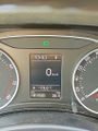
According to the car's thermometer, the temperature was −19 °C.
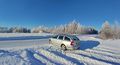
The car parked by the road, 50 metres to go.
The field road leading towards the hashpoint.
Proof of location and time, screenshot from QDGN.

Stupid Grin™
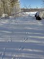
Hare tracks on the snow.
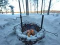
Grilling sausages on the fire.

Voting in today's presidential election. This is the empty ballot paper; I filled it in after taking the photo.


Achievements
Kripakko earned the Land geohash achievement
|
Kripakko earned the Frozen Geohash Achievement
|
Kripakko earned the Democracy Geohash Achievement
|