2024-02-13 -37 145
| Tue 13 Feb 2024 in -37,145: -37.7912502, 145.2711300 geohashing.info google osm bing/os kml crox |
Location
The fenceline of Alto Reserve, a small park in Croydon, Melbourne
Participants
Expedition One
- Pwc (did not attend, too lazy)
- pwc's co-worker
- pwc's co-worker's wife
Expedition Two
Plans
Expedition One (pwc)
I checked in the morning and thought about doing it but it seemed too far and/or I was too lazy. Therefore convincing other people was the only way.
Expedition
Expedition One
pwc checked the geohashing in the morning before setting off to work. It looked do-able, but (a) a reasonably long ride, (b) on a work day, and (c) on a day forecast to have severe thunderstorms and bushfires. It could also be done by train, but Croydon Station is temporarily closed, and I had visited the area the day the station closed (for train nerd reasons) and ridden home from there and so was too lazy unable to do it again.
However, my co-worker lives in the area. Obviously, the solution was to convince him to do it. Accordingly, I spent the day subtly discussing the adulation, fame and Internet points that come from participating in geohashing. Free beers may also have been offered. (I also tried to convince my boss that he could make my co-worker visit the hashpoint as a job requirement, but apparently this “violates Australian industrial relations law”.)
It is reported that the hashpoint was reached successfully, by both my co-worker and his wife. I am told that the intrepid hashers had to climb the fence to get in to the park, and only after some bush-bashing realised the hashpoint was precisely on the fenceline and could easily have been done from the road.
Expedition Two
I noticed in the afternoon during my lunch break at RMIT that the Geohash for that day was very attainable. So after my studies were done, I ventured forth!
First of all, Melbourne Central Station was packed. There were lots of delays, and something about "areas affected by fire". Ominous. But also very normal for Australia - you check your forecast in the morning, it says there's going to be fire, and you're like "ah yeh". At least from my vantage point, it seemed as if the Glen Waverley trains were the bottleneck on Platform 3, holding up that line as well as the Belgrave and Lilydale trains sharing the platform with it.
I was eventually able to board a Lilydale train, but took note that it was not stopping at Croydon (which is exclusively on the Lilydale line), meaning I needed to make the rest of the journey a different way. I later noticed that a fair number of trains weren't stopping at Croydon, making it seem like the East Richmond Station of the Lilydale line.
For those that aren't from the Eastern Suburbs, the words "East Richmond Station" evoke an image akin to a radioactive wasteland or a barren desert to us, because the Belgrave and Lilydale lines servicing us almost never stop there. The other train lines do, but not ours. If we hear "Now Stopping at East Richmond", we immediately choke on our oat magics and screech that the end times are near (I'm just kidding of course - us peons in the Eastern Suburbs are too pedestrian for such fancy inner-city coffee orders).
I got off at Ringwood, but first I had to address my very low phone battery and the fact that I forgot to bring a charging cable. I sped into Target at Eastland at very last second to snag a cheap one and it took like 20 minutes to get my phone to the minimal amount of charge to boot up again. Luckily, I could leave it charging in my backpack from my laptop. Feeling like a champion of overcoming First World crises today; I'll even have you know that earlier today, a restaurant got my takeaway coffee order wrong and I told them that I didn't mind.
I tried making it the rest of the way from Ringwood to the Hash via Route 380 only to find that the bus stop location had been temporarily changed but not reflected on Google Maps. Went for the 670 instead. Got there nice and easy, and the bus stop was closer to the Hash than any others' could have been.
Finally, I got to the park. Made the same mistake as Pwc's friends and mistakenly thought it was over the fence, so I may have very cautiously and lightly stood on some protected plants for nothing. Oops.
Oh, and I got a good look at the whole outage stuff. Yeah, entire suburbs have lost power. Felt kinda self conscious snooping around taking photos, because there were lots of people sitting on their porches with nothing they can do.
Got a better look at the rest of the outage on the way home, commuting via two buses that traversed streets with no working traffic lights. People got the hint and drove quite cautiously, so it worked pretty well. I had no signal at the interchange between the two buses, but being the Queen of First World Problems that I am, I managed to decipher the ancient runes and figure out when the next bus would arrive. Then I got home and watched funny Internet videos in my air conditioned house.
Photos
Expedition One
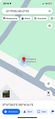
Screenshot of proof

Expedition Two
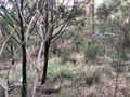

GPS Proof

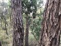
Hash Pano!

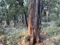
Hash Selfie!


Achievements
BarbaraTables earned the Land geohash achievement
|
BarbaraTables achieved level 2 of the Minesweeper Geohash achievement
|
BarbaraTables earned the Public transport geohash achievement
|
BarbaraTables earned the Queen of First World Problems achievement
|