2024-03-04 32 35
| Mon 4 Mar 2024 in 32,35: 32.6479362, 35.0611468 geohashing.info google osm bing/os kml crox |
Location
In a set of suspiciously young-looking and orderly trees in the center of the Carmel National Forest, north of Elyakim.
Participants
Plans
Train day! I have a doctor's appointment at 08:30, but depending on when I'm done, I'll take a train to the general area, then a bus to Elyakim, then walk to the point.
It will almost certainly not be as simple as all that.
Expedition
The doctor's appointment ended a few minutes too late to catch the 09:09 train from Jerusalem, so I took the 09:39 train instead.
Moovit was not being cooperative; as much as I hate Google, Google is more respectful of my desire to have a mostly-train journey, where Moovit thinks it knows more than I do and kept recommending bus routes just because they're "shorter". Screw that!
Unfortunately, this meant I screwed up multiple times on the trip. At Ben Gurion Airport I switched to the Modi'in-Nahariya train (because of its far more comfortable seats and better laptop tables), then switched in Atlit to the train to Beit She'an, then got off the train at Yokneam, then took a bus to Yokneam Illit, then took a bus to Elyakim.
I'm sure there had to be a faster way to do that. I didn't make it to Elyakim until after 1pm.
I have recently decided to challenge myself more often with getting as close to the point as possible without GPS. I had two printouts: a level 16 road/trail map and a level 19 satellite photograph (the levels are from geohashing.info). The plan was to use the level 15 map to get to the right area, then the level 19 map to find the specific spot amongst the trees.
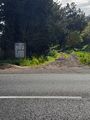
So I started with a walk up route 672 until I found a gas station. This immediately put me in a bit of a spot, because the gas station wasn't really visible on the printout. I guessed that I should go north through the parking lot, and immediately hit the east-west path. I went east, not knowing which path I was on, until I saw that it hooked to the right (south). That's how I knew I was on the north of the two paths going east of 672:

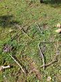
Next I hooked south, crossed a cattle grid, hooked east, and went back north again. I saw the two paths that are headed east, so I knew where I was and that I needed to keep going north. Cross another cattle grid. There are cows. And at this point the hill gets *very* steep.

Then it levels out and hooks west. And before long I was presented with a triple fork in the road: west, south, and north. Which confused me, because there's no such fork on the map. Where was I?
Okay, there are power lines above me. That implies I'm at point 1. But I could've sworn I walked farther than that. Maybe I'm at point 2? The west path looks like it hooks north, just like the purple line does. But that's not a path, that's a district boundary. Maybe there's a path on the district boundary?

Later I would discover that I had actually been at point 3, and the north and south paths aren't on the map. But I thought I was at point 2, so I took the north path.
Which ended after a short time and turned into a path of loose rocks. This was confusing but... okay? Maybe the path is now made of rocks?
I climbed the rocks. And eventually realized that there was no way this was the path, and I was in the middle of nowhere.
Okay - new plan. I know where I came from, and I know I need to generally head north, and I know which way north is thanks to the sun. Conveniently, north is also uphill, which means I'll have a better vantage point from which to see other paths. So I'll go north. Worst-case scenario, I'll head back south; I have an excellent visual memory.
I head north more, and more. There are cows everywhere (this is a massive grazing area), and a mysterious "pop", "pop" sound in the distance off to the southwest. I start to suspect that I might be farther west than I thought, and I might end up hitting route 672 again.
But then I reach a path! And the path goes east-west, and hooks north at both ends. Which path is it? No idea! But I go west. I don't know which of points 4-7 I'm on, but I suspect it's 4.

I'm tempted to give up and open the GPS. But I resist temptation and keep going west, then north - and I see that the path meets another one, in a configuration that only matches one intersection on the map. I know where I am now!

I head south, then west at the next intersection. I pull out my satellite map. I look for the right place to turn off the path - it's obvious. I come across a grove of very regularly planted trees, just like in the satellite photo. I start counting trees. I get to the right spot, I pull out my GPS, and...

DAMN, am I good!
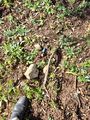
A few steps to the side and I'm at the point. On the ground, almost exactly at the point, is an animal bone:
I sit down, exhilarated. Then I photograph the bone and send it to my wife, jokingly asking if I should bring it home. By the time I finish laying out xkcd with branches I get the answer: yes. Yes?! You're serious?! Yes. She's serious.
Sigh. Artists. They're all insane. Not like us geohashers climbing mountains for no reason. We're sane.
I pull a plastic bag out of my backpack and grab the bone with it, wrapping it carefully. I also send the picture to my brother, a radiologist, asking if he can identify it.
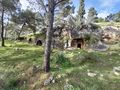
Time to go home. This is a bit of a problem, because this is when the GPS jamming started telling me I'm in Beirut. But since I'm not no-batteriesing it anymore, I can zoom in and out on satellite photos of the area and compare them to my surroundings. I take the path down part of the mountain, then a direct route down the rest of it. On the way I find some ancient burial caves; I'm no expert, but they're probably Second Temple-era.

Eventually I reach the picnic area. From there, bus to train, train to home.
Sadly, the security people at the train station utterly failed to ask me why I had the broken humerus of a wild boar in my backpack.
Photos
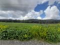
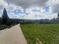
That's the mountain I'm going to climb
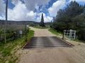
Cattle grid. People and cars can pass. Cows are too stupid.
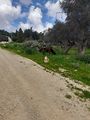
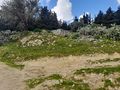
Cows and cacti
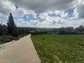
Halfway up the hill
Same photo
Some ancient structure
How did a printer cartridge get on top of this mountain?

I got this far on no batteries!

Proof
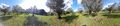
Panorama at the point
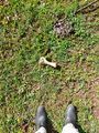
Animal bone on the ground. Cowpie above it.
Badly made xkcd
Burial cave entrances
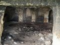
Inside the burial cave
Danger: Live fire zone. This was the source of the "pop" "pop" that I've been hearing the whole time.


Achievements
Is it true that Yerushalmi earned the No Batteries Geohash?
|
Is it true that Yerushalmi earned the Leap geohash achievement 5784?
|