2024-03-16 28 -82
| Sat 16 Mar 2024 in 28,-82: 28.5336939, -82.4858968 geohashing.info google osm bing/os kml crox |
Location
A grassy berm between the sidewalk and Cortez Boulevard in Spring Hill, Florida
Participants
Plans
Two GeoHashes in one day using a route calculated as if I was bicycling (est 15.5 hours for 186 miles) using my car (approx 4.5 hours for 173 miles)
Expedition
(See 2024-03-16_28_-81 for the first part) The directions for hashpoint 2 were very straightforward if I used the car route. However, the bike route was much more interesting as it kept me on less traveled and historic roads. That also led to several instances of getting to the end of a road and being required to turn around because there was no further road, just a single-lane track. In the process, I passed a field of Florida cattle including several with impressive horns and traveled 5-10 miles of clay and/or sand roads. I planned to visit a historic spot (Richloam General Store) in the process but the multiple backtracking ended up having me arrive too late to do more than look at the outside. When I left the site around 5:15, I decided it was time to quit traveling slowly and get the trip finished, so changed the route to take the main roads. I arrived at the second hashpoint just at 6 pm. I parked in a nearby church parking lot and walked about 140' to the exact point. Once I finished celebrating having reached the hashpoint, I stopped at a new Pho shop (VN Pho, Spring Hill) for supper, then headed home, arriving there at 8:30 pm.
Photos
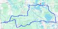
The Plan
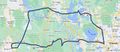
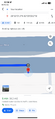
Actual Tracking
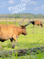
Florida cattle
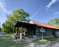
Richloam General Store
28.53369, -82.48590

Sunset on a long successful day


