2024-03-17 -37 144
| Sun 17 Mar 2024 in -37,144: -37.6140593, 144.6268826 geohashing.info google osm bing/os kml crox |
Contents
[hide]Location
By the side of a road near Toolern Vale
Participants
- John
- Bridget
Plans
I had my eye on this hash, by the side of a dirt road between Diggers Rest and Toolern Vale. I was ready to have a nice longish cycling hash expedition, but Bridget wanted to go for a bit of a day/half day trip out to the beach or something. The obvious compromise was to find somewhere nice to visit, if not a beach, near the hash and drive out and visit the hash on the way. After a bit of research, we decided that the Happy Valley track, by the Pyrites creek, within the Long Forest Flora and Fauna Reserve looked ideal.
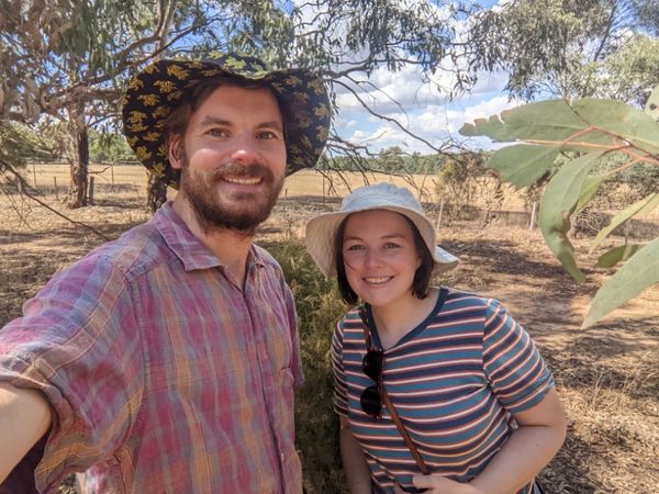
Expedition
We drove out up the Calder, and at Diggers Rest headed west. Soon we needed to turn right onto Ryans Lane, the dirt road that the hash lay to the side of. Just a few hundred metres along, it was time to pull over. The road had a nice wide reservation on each side before fences would be any obstacle, plenty of room for the hash to be located! We found the spot, snapped a pic, and hurried on our way. Even though we were on a public road, Bridget was keen to get moving, still a little nervous that landowners might notice and interrogate us.
We drove on to Long Forest, overshot the carpark due to an impoverishment of any sort of signage, but managed to sneak in on our second pass heading back the other way. We then went for a lovely walk. The bush was warm and dry, the creek wasn't running, but there was enough water sitting in pools that wildlife was in no short supply. We saw a snake having a dip in one such pool, saw a kangaroo having a lazy lie down by another, and throughout we saw many good birds, and innumerable butterflies. Avian highlights were a yellow tufted honeyeater, a female rufous whistler, a spotted pardalote and two types of robin, an eastern yellow robin, and a scarlet robin.
Photos
Success!

Gps proof

