2024-03-20 65 25
| Wed 20 Mar 2024 in 65,25: 65.1141267, 25.7053581 geohashing.info google osm bing/os kml crox |
Location
Next to a skiing track near Vaartinkangas, Kiiminki, Oulu.
The point on a topographic map: [1]
Participants
Expedition
This was a nicely accessible point reasonably near the city, though in practice it would be necessary to drive most of the distance. I could have taken a bus, but it would have taken more than an hour each way while driving would take less than 20 minutes. Cycling would have been even less convenient. Since the hashpoint was next to a maintained skiing track, the only appropriate way to get there was to ski there. Well, as I found out when I got there, there was also a snowmobile track on which I could have walked, but I liked the skiing option anyway. The skiing distance from the beginning of the track to the hashpoint was about 700 metres, which felt a bit short, so I decided to ski all the way to the skiing track intersection in Honkimaa and turn back there, which would be an appreciable exercise.
Once I was back home from work, I relaxed for a while and then set off.
I drove towards Kiiminki, and my plan was to park in the parking area of the house of the Association of Peace.
The skiing track started from a corner of the courtyard, so it would be a convenient parking spot.
When I got there, I saw a big no parking
sign with a map of the courtyard,
and my immediate assumption was that parking there without a permission was prohibited.
I knew that there was a graveyard a hundred metres away with very likely free parking, so I went and parked there instead.
When I walked to the house with the skis, I noticed that the sign actually meant do not block the roads or doors by parking stupidly
or something to that effect.
Oh well, I did not know, though I could have guessed that parking next to the skiing track would be allowed and been correct.
Indeed, there was a row of cars parked there.
I almost felt a bit stupid.
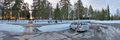
I originally planned to visit the hashpoint on the way back, but when I skied by it, I realised that the sun was about to set. The dimness of twilight would begin soon, so I decided to stop then and take photos while there was still enough daylight. Getting to the point itself was not difficult at all: the crusted snow could support me as long as I stood on the skis, so I could just hop off the track and ski a few metres to the point. When I took one of the skis off for the selfie, my foot immediately went through the snow and I almost fell. I then had to stand on the one ski with both feet so that I had a stable footing.
The skiing track was in an excellent condition. Even though the air temperature was about 1–2 °C, the surface of the snow was frozen and packed hard, which made the skis glide very well. Softer snow would have made the skis a little more grippy, which I would have liked, but this allowed me to double-pole much of the way. It is so much fun when you find the rhythm, keep your balance and gather some substantial speed. I got to the intersection and, as planned, turned around, skied back to the starting point and finally walked back to the car.
This trip was also a real-life test of the recently improved version of QDGN which worked perfectly to my expectations. I was able to document reaching the hashpoint and to record a tracklog without any issues. After analysing my route, I concluded that I drove about 40 km, walked 0.6 km and skied 6.7 km.
Tracklog
Photos
The parking area where I parked the car.
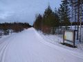
The beginning of the skiing track, photographed on the way back.
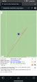
Proof of location and time, screenshot from QDGN.
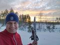
Selfie at the hashpoint.
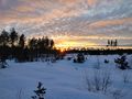
The sun is about to set.
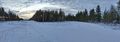
The intersection of skiing tracks where I turned back.


Achievements
Kripakko earned the Land geohash achievement
|