2024-05-11 46 -70
| Sat 11 May 2024 in 46,-70: 46.5800480, -70.9747232 geohashing.info google osm bing/os kml crox |
Location
In a field in the town of Saint-Anselme.
Participants
- Gict
- Gict's boyfriend
Plans
On Friday after studying the coordinates for the weekend, I decided that this one would be accessible enough by the Cycloroute Bellechasse to be attempted. The plan is to drive to a parking and ride to the hashpoint. The boyfriend will be coming along if he repairs his bike in time.
Expedition
After noon, the boyfriend had repaired his bike and we were ready to go.
The Cycloroute Bellechasse is a 74km long bike path, so we had many parking options. I chose one in Saint-Henri 15km from Saint-Anselme where the haspoint was. For a planned total of 30km, the max the boyfriend had agreed to do. We started on the path southbound seeing everyone coming northbound. Turns out we were in for a slow ascent of 15km and they were all coming downhill. Bit discuraging but it will be good for us on the way back.
In the first 2km, the boyfriend's back wheel started touching the frame. We stopped to fix it. In the next kilometer, the gear would not switch. We stopped and switched it by hand. He was now stuck on the big gear in front but we rode without any other issue. We passed a lot of wildlife: birds, squirels, and even chickens. The bike path is not along roads, instead crosses fields so it's peaceful. There was also not a lot of other users.
We arrived at the closest spot of the path to the haspoint at about 4 pm. I got down the path through a field and then got to a ditch full of water. The water didn't seem very deep but I walked to the right hoping to see an easy way across. I stopped at one point and decided to get through with a branch. My idea was to step one foot on the branch and then across. The branch broke. The ditch was deeper than a tough, what seemed to be 10cm of water was 30cm of smoosh mud. My other foot was still dry when I stood on the other side.
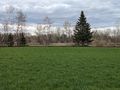
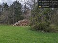
At this point, I was 20m to the haspoint. Walked there, took my picture, and turned around. It was only a field with some cut wook well organized close to it. For my way back, I walked to my right who was my left prior and the ditch was way more narrow that way... The boyfriend laughed at me for being clumbsy and not patient enough to have seen all my options. We exchanged water supplies and got on our way back. Downhill all the way, it was smooth. Total of 36.55km.
This expedition was the first recorded in this graticule 🥳
Tracklog
Photos
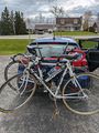
The bikes
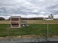
Chickens
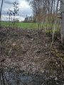
Across the ditch
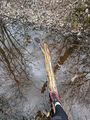
Before it broke
Where the bikes and the boyfriend waited
The hashpoint @46.5800,-70.9747


Achievements
Gict earned the Graticule Unlocked Achievement
|
Gict earned the Land geohash achievement
|