2025-02-20 50 14
| Thu 20 Feb 2025 in 50,14: 50.1100496, 14.4832857 geohashing.info google osm bing/os kml crox |
Location
In a forest near Kolčavka, Prague.
Participants
Plans
I plan to do an expedition after the workday. I have not decided a schedule since there is frequent public transport, but I will probably be here around 6 pm.
It is not obvious from where to approach. I will likely take a tram from the city centre to Divadlo Gong, walk to Podvinný mlýn, enter the forest and arrive from the east. There seems to be an abandoned railway that I can follow for a little bit. Another option would be to enter the forest in Kolčavka, see the ruins of a bridge of the abandoned railway and approach from the south, but it is probably not as practical and might arouse suspicion in the locals. Yet another option would be to approach from the north and cross the railway tracks, but it is not any more practical either. I am not sure, but crossing the railway might even be illegal.
Expedition
As usual, I took bus 331 from Vestec to Opatov metro station, after which I took metro C to Florenc. I then tried to find the best way to get to Divadlo Gong using the PID Lítačka application and saw no very good options. An acceptable option was to transfer to metro B, ride it to Invalidovna and wait for tram 12, so I did that. I got off at Divadlo Gong and started walking to the north, crossed the Rokytka stream and looked for a trail leading to the abandoned railway. Where it was drawn in OpenStreetMap, there was only impassable forest, but I soon found it a few metres off. (I guess I could update it based on my GPS track if I managed to figure out how to do it.) I climbed uphill and ended up on the abandoned railway where all kinds of were trash scattered all over. There was even a tent canvas that had been put up like a crude shelter. I followed the track to where the bridge had been and just barely managed to take photos of the surroundings. It was already getting dark, and there was just barely enough daylight for taking photos in the open. None of them turned out very good.
I turned back and headed for the hashpoint. The terrain was surprisingly uneven; I had to descend to a hollow and climb another uphill. Once there, I was surprised to see that I had entered a tent village of homeless people. There were no options but to walk through, which I did as quietly as I could, and did not see or hear any sign that anyone was there. I found a trail that went near the hashpoint and finally walked in the forest for the last few metres. The hashpoint was in a reasonably accessible forest where I could walk around without much difficulty.
On the way back, I had to walk through the tent village again. This time, I heard and saw someone moving in a tent (they had some light source inside, so the moving person cast a shadow in the tent canvas), but I was already walking away fast enough that they would not be able to catch me even if they tried. I was not too scared for my personal safety, but losing the contents of my wallet or my backpack would have been a huge inconvenience. I got out of the forest and walked back towards the tram stop. While walking, I looked up the tram schedule and based on it thought that I would have about ten minutes to spare before the next one would arrive. However, when I got there, I was surprised to see a tram arrive and depart mere seconds before I got to the stop. Apparently the tram schedule had been updated on this week's Monday, and the schedule in the app had not been updated yet. Oh well, the next one, number 31, would arrive in a few minutes, so I rode it to Palmovka metro station, took metro B to Florenc, metro C to Kačerov and finally bus 138 to Krč. Even though the trip was not very long distance-wise, it still took me almost three hours in total.
Tracklog
Blue = bus and tram, red = walking, black = GPS signal lost in the metro.
Photos
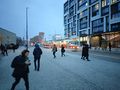
The outgoing tram.

Something I did not expect to see: University of New York in Prague.

The stream (Rokytka) that I crossed.

The abandoned railway.

Something looking like a crude tent put up on the abandoned railway. A lot of trash all over.

View from the ruins of the railway bridge.
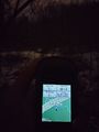
Proof of location.

Proof of date and time.
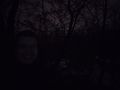
Selfie in the dark.
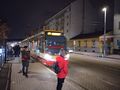
The returning tram.


Achievements
Kripakko earned the Land geohash achievement
|
Kripakko earned the Public transport geohash achievement
|